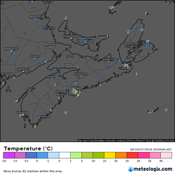
April 29th Mid Day Update: Increased Fire Weather, Smoke, Some Showers And Wild Temperature Swings.4/29/2024  In our Mid day update today, we will be focusing a lot on the Fire conditions and Fire weather, For latest forecast you can go to our StormTracker Forecast page! where the 7 day forecasts for 8 regions are updated and the 24 hour forecast. Looking at the latest Satellite/Radar + Smoke Particles, We can see a lot of red dots over Northern Nova Scotia, this is showing where there are some fairly high smoke particles in the upper atmosphere. Hazy/Smoky skies can be seen over Northern Nova Scotia.  We have a lot of clouds out there at the moment over much of the province, and that is because we have a very weak system located near Guysborough County, A weak low pressure with an occluded front, We also have a Cold front that stretches down from Labrador to Northern New Brunswick, this is bringing clouds and some cooler temperatures, it also brought rain showers to some part of the province this morning. There is a very large High pressure located over in Quebec, and this will bring a lot of sunshine and nice temperatures to most of Southern Nova Scotia tomorrow! however, cooler and cloudy conditions expected in the North. 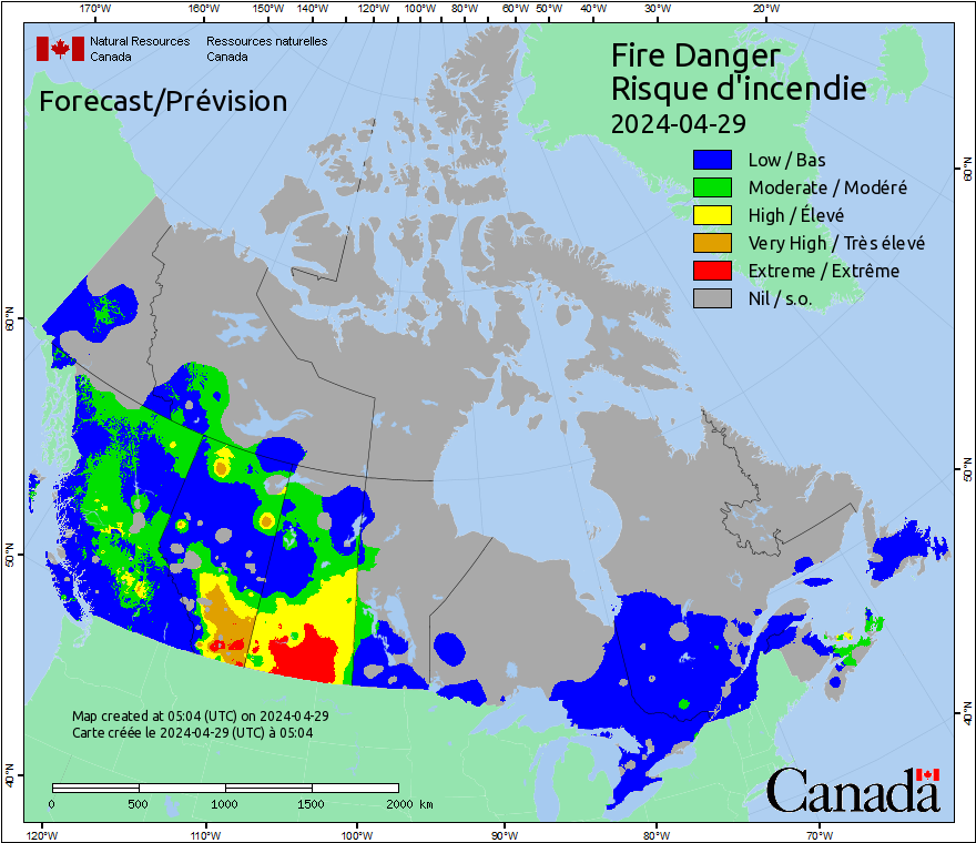 Currently there is a Low to Moderate fire danger risk, highest over Northern NS and Cape Breton. There is a Very high and Extreme fire risk out on the Southern Prairies right now! 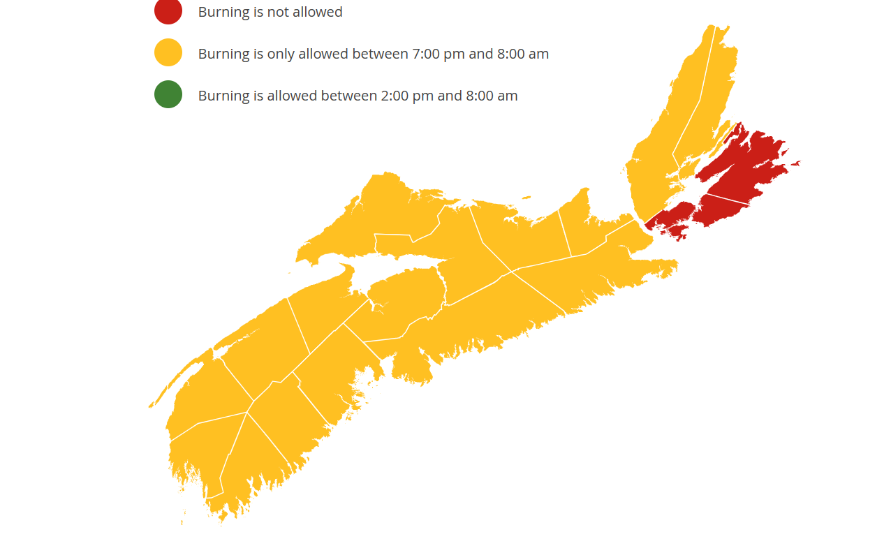 The province wide fire ban that was in place yesterday and earlier this morning, has been lifted to almost everyone, the only exception is Cape Breton East, where in Cape Breton County and Richmond County, a no burn ban remains in place. Everywhere else, where it's Orange, is under Restricted burning, burning is only allowed between 7PM and 8 AM. 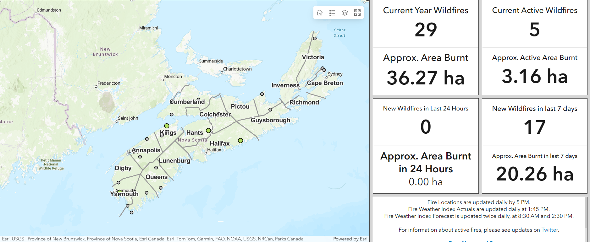 Currently, we still have 5 active wildfires burning in our province, 2 are in Yarmouth County, 1 in Kings County, 1 near the border of Hants and Colchester County, and we have 1 in Far North Eastern Halifax County. In the last 7 days, so just this week alone, there has been 17 new wildfires! Luckily, there has been no new wildfires in the last 24 hours. The wildfires in Yarmouth County have been burning for the past 2 days now, since April 27th, and have burned up to 1ha, the fire is considered under control. The Wildfire in Kings County near North Mountain, has been burning for almost 5 days now, since April 25th, the fire is small and has only burned 0.25 ha so far, the fire is considered under control. The Wildfire in Hants County near the Colchester county border, has been burning since yesterday, So far it has burned 0.90ha and is under control. The Wildfire in Halifax County halfway between Tangier and Sheet Harbour has been burning for the past 2 days, since April 27th. This fire has burned 1ha so far, and is also under control. 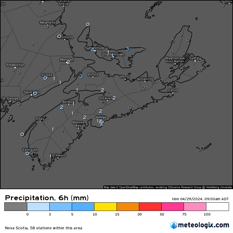 We had some rain last night, between the hours of 3AM and 9AM this morning, a trace to 3mm has fallen over Southern and Mainland Nova Scotia. Not enough to help with the fires! 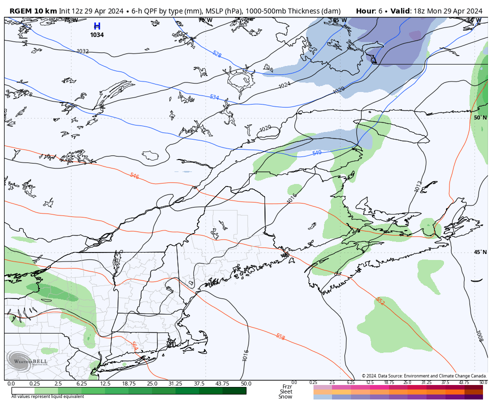 Will we see anymore rainfall to help out in the fires or bring the risk of them lower? well yes and no, There will be a chance of showers today, more so likely in the Valley and Western Nova Scotia and parts of Northern Nova Scotia. Unfortunately, these will be very light, and wont accumulate to much at all. 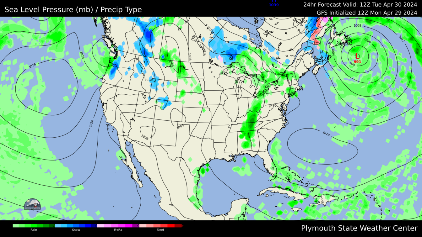 Fast forward into Tonight/ early tomorrow morning, the ocean storm looks to pass closer to us, and bring colder air down with it, looking like we could see some light snow flurries or light snow over Northern and Western Nova Scotia. 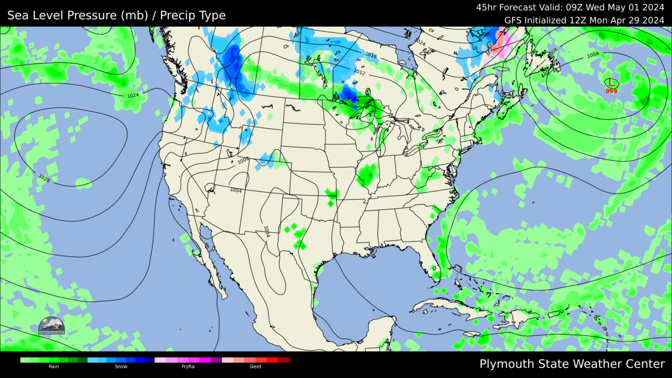 By Tuesday Night into early Wednesday morning, a weak cold front will produce some showers over the province. some of these MIGHT be more steady, but overall, they will be very light, and little accumulation is expected. 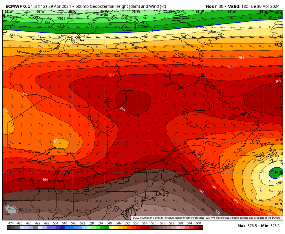 Upper air conditions at 500mb, We have that cut off low pressure/ trough south of Newfoundland, this is bringing North-Westerly winds which will keep things rather cloudy and cooler tomorrow, there is a nice ridge farther south of us, This will stick around with us for a good while, at least through Friday! 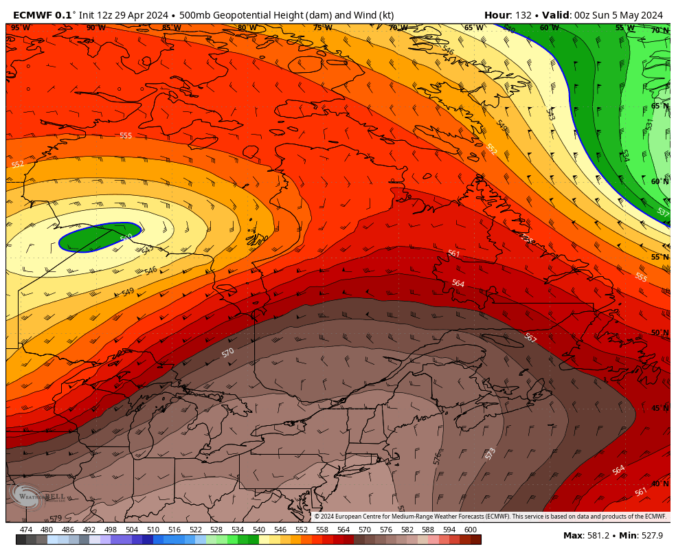 By this weekend, we will see a change in the weather! A large Ridge will bring warmer and even slightly humid conditions for the weekend into early next week. 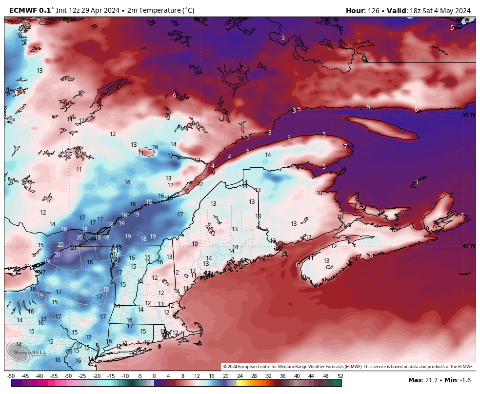 Temperatures on Saturday will be in the low to mid 10's. With the warmer temperatures just to our West and South. 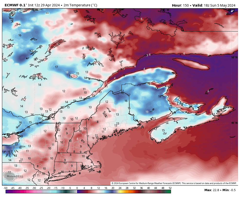 On Sunday, temperatures will be even warmer in the mid and upper 15's! coolest along the coast near the water! Northern Nova Scotia could see temperatures reaching near 18 degrees! In New Brunswick, a very warm day is expected there with temperatures flirting with 20-degrees. 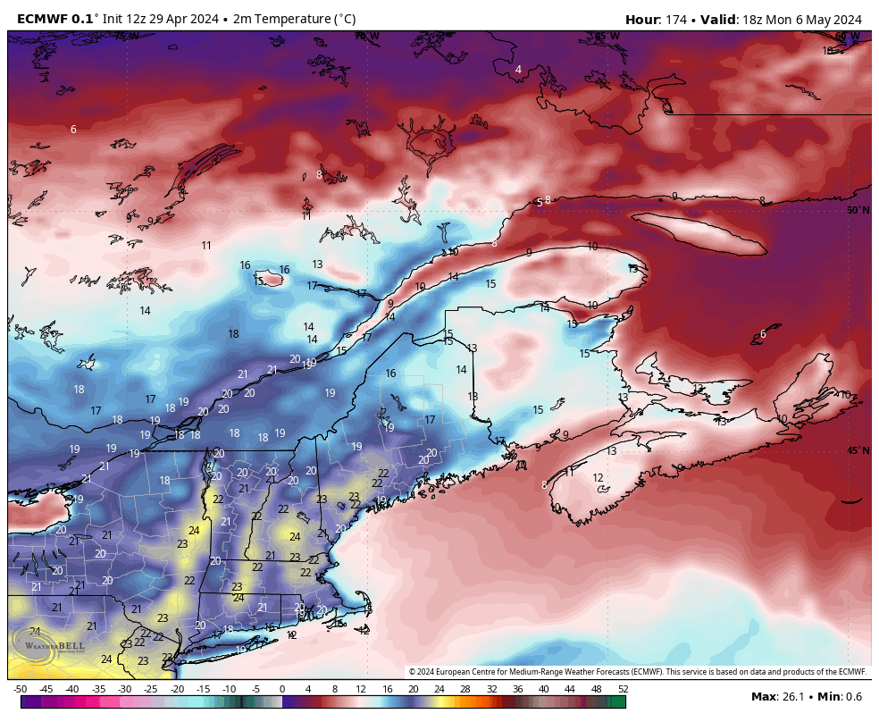 On Monday of next week, there will be a slight cool down! temperatures into the low 10's, but look what is south of us! low and mid 20's! from Maine to New York! This will head our way for Tuesday and Wednesday of next week! 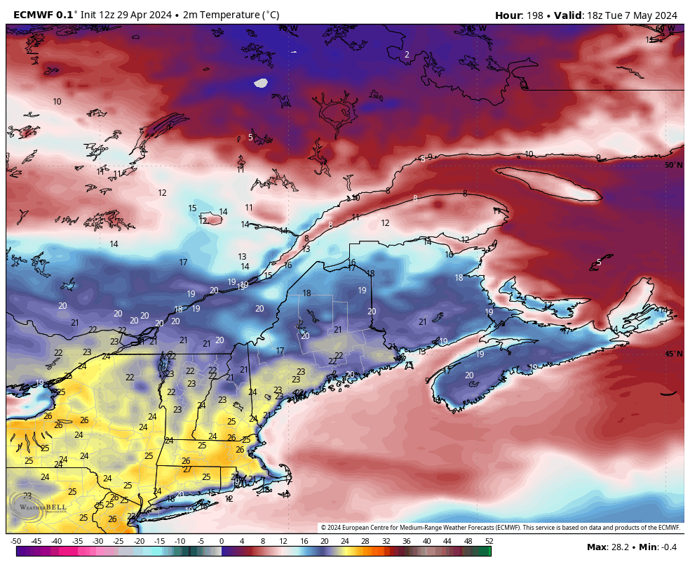 Tuesday is when temperatures really start to warm up! highs on Tuesday will be in the 18 to 24 range! Warmest in the South Shore. Check out those yellows and oranges over in PA, NY and MA. Mid and Upper 25's!!! could have feel like temperatures in the low 30's. For us, we'll have a little touch of humidity to bring a feel like temperature of 26 to 30 in our area.
So if you're craving the warmth, don't worry it is coming! temperatures will soar near 20 by the weekend!
0 Comments
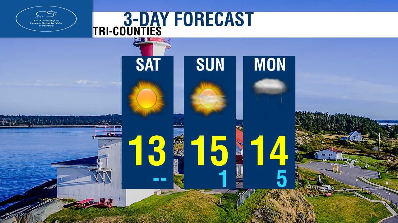
 Another cold morning out there it was this morning! Temperatures at 6AM this morning bottomed out at -8 degrees over in Collegeville, -6's in Upper Stewiacke and Malay Falls, -5 in Parrsboro and Debert in Western Nova Scotia, almost everyone in the province was below freezing. Only warmest areas was folks near the water, as the winds off the water pushed the warm water temperatures along the coast, temperatures along the coast just barely hanging on to above freezing. 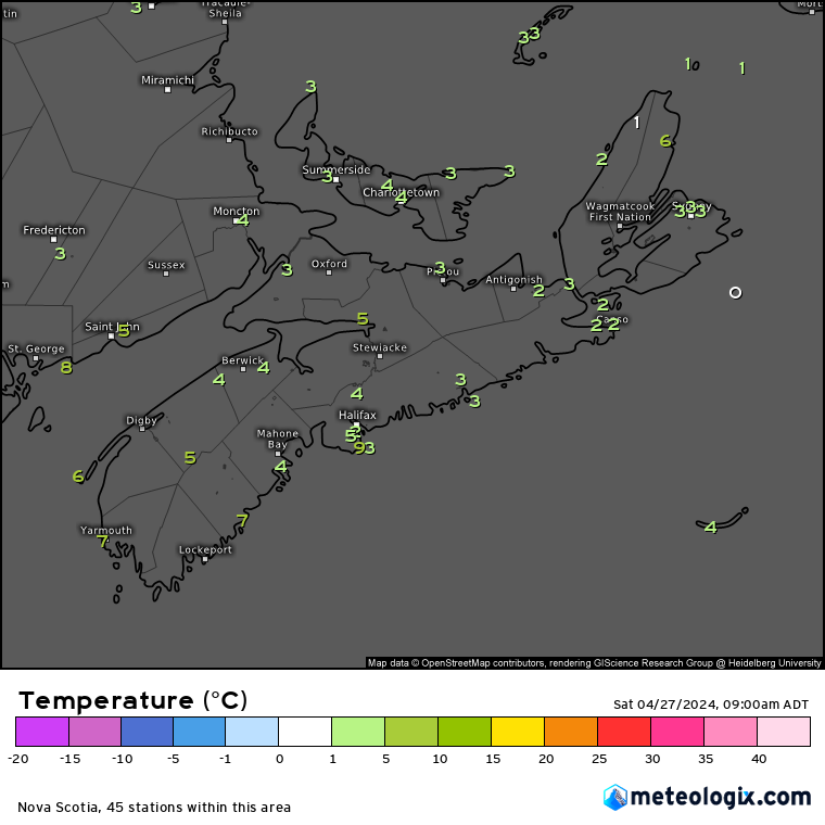 Fast forward to 3 hours later, as of 9AM, temperatures have rebounded big time, we have the strong April sunshine to thank for that! Remember, that April sunshine is about the same as in August! so the temperatures climb very quickly in a few hours in the morning, the sun is also strong, so High UV readings, and risk of sunburn increases. Temperatures out there right now as of 5AM, we're at 7 in Yarmouth, 7 in Western Head, 6 on Brier Island, 3-5 in Halifax County and Metro. 2-4 degrees over much of the mainland, 3 in Cape Breton County.  We have a lot of sunny skies out there once again, and it's thanks to a stationary high pressure. We're sandwiched between 2 storm systems, one large system over the Great Lakes and the other off the coast of Newfoundland. and in between is a High pressure keeping the Maritimes and East coast dry. We have this Large High pressure over us, with a large high pressure gradient, pressure over 1035mb, But there is a Stormy Low pressure over in the Mid-West US States, as well as a large cold front stretching from Hudson Bay to the Northern US states and Interior of British Columbia. 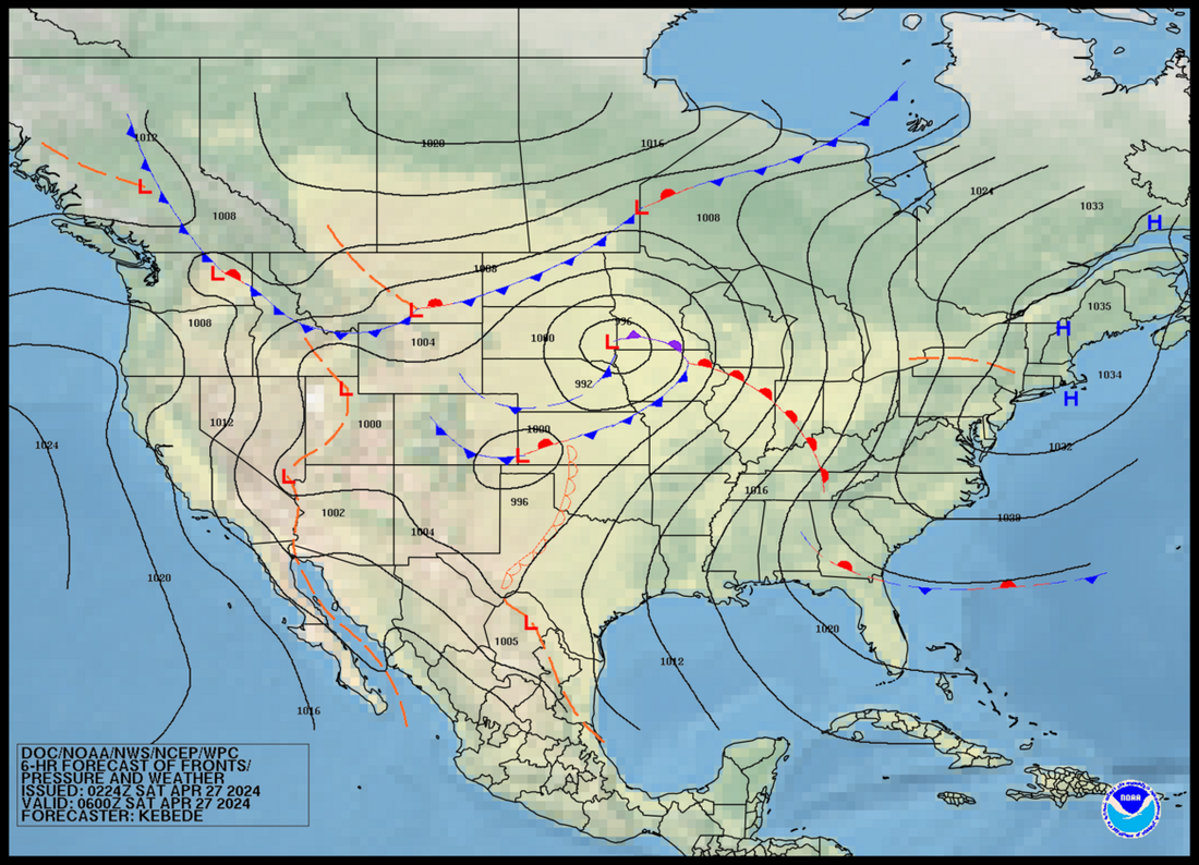 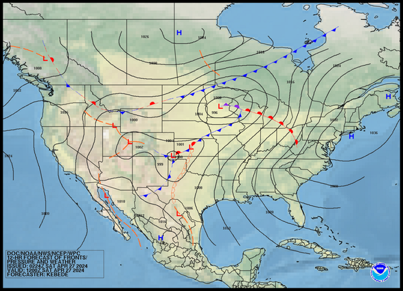 By later Today, High pressure holds control over us, Thundery showers and Gusty winds takes hold over the Great Lakes and much of the 4 corner states. Large High pressure over Western Canada bringing sunshine, but a cold front passing through Hudson Bay will bring cooler temperatures. 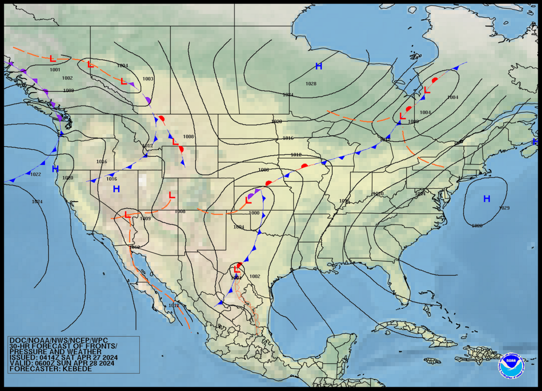 By Tonight, Looking at High pressure weakening a little but still holding strong over the Atlantic, this will bring us clear skies, another cold night as well. The Great Lakes storm moves over Quebec/Ontario border south of Hudson Bay, meanwhile High pressure brings cold clear skies over the prairies, but a Low pressure develops over Western Canada to bring Unsettled weather and cooler temperatures.  Looking at Tomorrow Morning, Weakening high pressure will bring continued sunshine, but clouds will be on the increase into the South, the weakening High pressure will allow the Cold front over Quebec stretching to the Mid Western States and down to Texas to bring clouds and showers as well as cooler temperatures Sunday Night into Monday, High pressure tomorrow morning over Ontario and the Prairies will bring more sunshine and comfortable temperatures, Continues to be unsettled in Western Canada with cool temperatures. 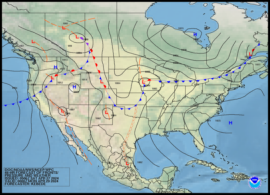 Looking at Sunday Night, the high pressure that brought us the gorgeous weather now much weaker and pushed far south near Florida, the cold front now located Southern Quebec bordering New Brunswick will bring showers to the Tri-Counties and The Valley, meanwhile cooler temperatures will follow on Monday. High pressure over Hudson Bay moves South, bringing breezy but cool dry weather over Quebec & Ontario, unsettled weather continues in Western Canada.  Monday Morning, Looking at a warm front over the Tri-Counties, this will bring mild and humid temperatures, but also some showers and fog. A cold front over the Bay of Fundy will bring colder temperatures Monday evening. Low pressure over the Great Lakes will bring more thundery weather and very warm and humid Temperatures, Feeling into the 30's for some parts of Southern Ontario. Low pressure that was in Western Canada moves into Alberta and Saskatchewan to bring showers and thunderstorms. High pressure moves in over BC to bring drier weather and North westerly cool winds which means cooler temperatures. Cold front over Northern BC will bring a chance of showers and chilly temperatures. 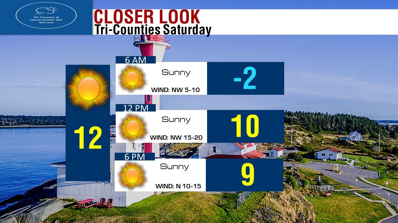 Looking at sunshine today all day long in the Tri-Counties and all of the province in fact! Temperatures this morning again starting off near or below Freezing. Will warm up to near 10 by Noon, and around 9 degrees by Supper hour. North Westerly winds 5-10 this morning will pick up to 15-20 this afternoon, winds turn Northerly this evening at 10-15 km/h. Highs in the Tri-Counties today will be around 12 degrees. 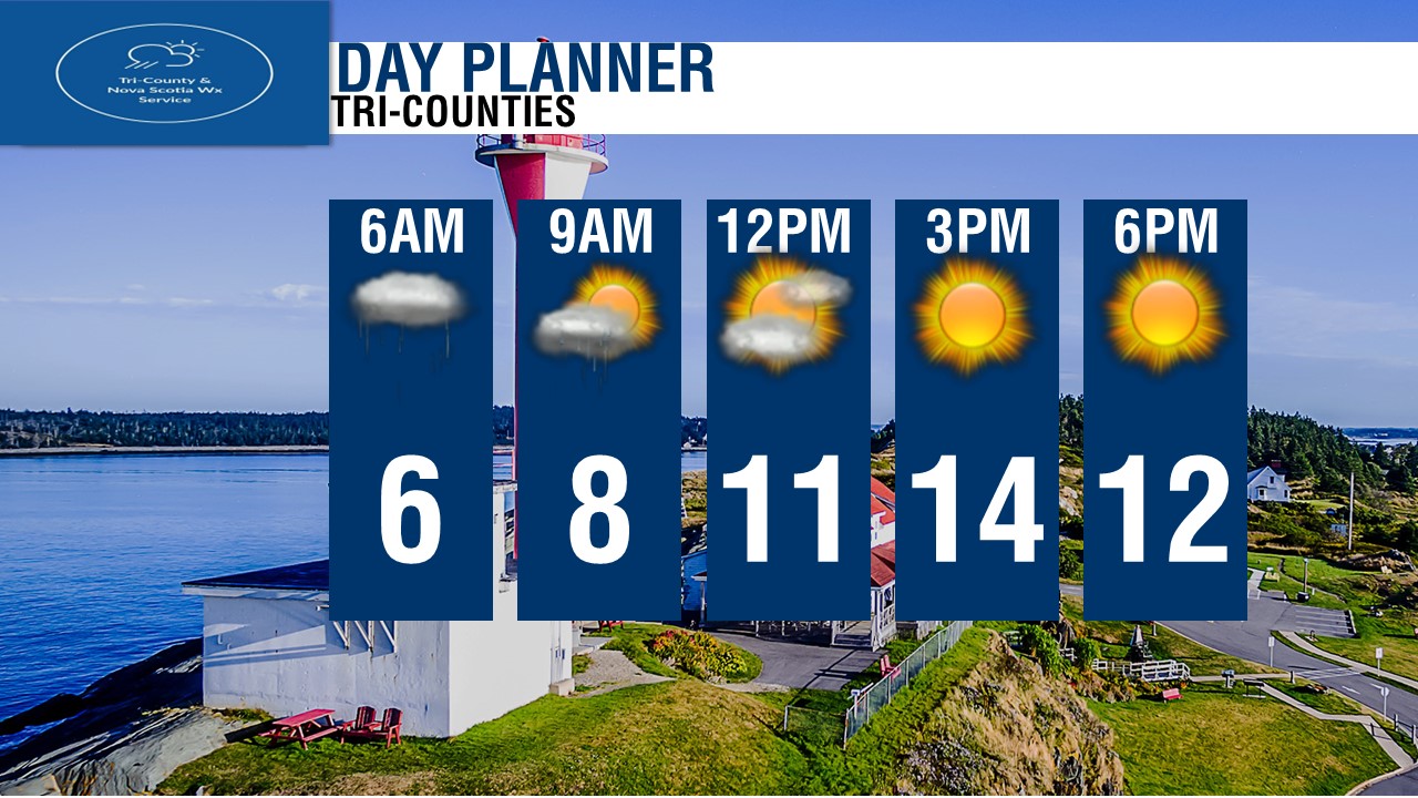 Looking at the Day Planner, Looking at Sunshine from start to finish, temperatures cold this morning, warming up nicely by this afternoon! 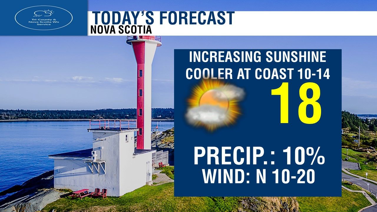 For Today, Wall to wall sunshine! highs of 14 in the warmest spots, coolest temperatures near the coast and in Northern Nova Scotia.  If you're in Halifax, and You're going to the Wanderers Soccer game against Atletico Ottawa, Before the game, we'll see temperatures near 10 degrees, we'll see sunshine for the first kick off at 3pm, and midway through the game we'll see sunshine and temperatures near 10-11 degrees. By time the game ends, we'll see sunshine and still near 10 degrees. Great Soccer weather! 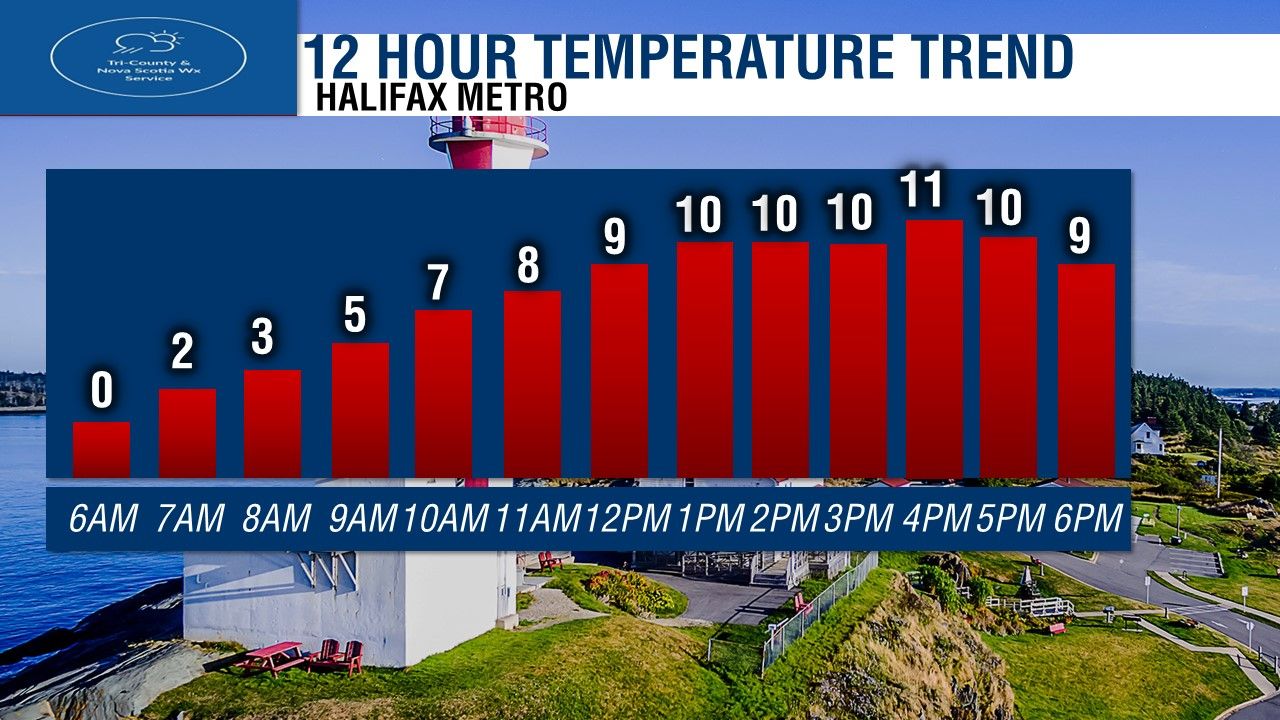 Temperatures in the Halifax Metro today, starting off Freezing, we'll see it warm up to 5 degrees by 9AM, then 9 degrees by Noon, and holding near 10 or 11 this afternoon. 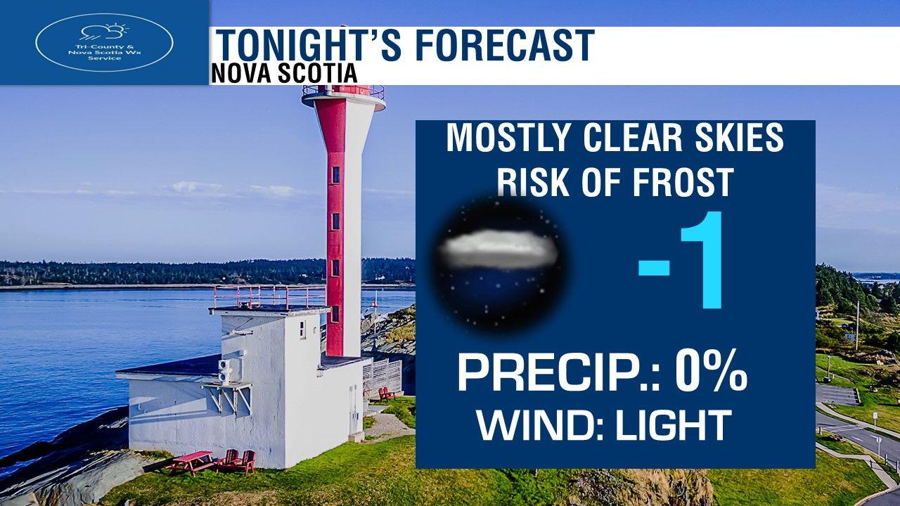 Tonight, we'll see clear skies and cold temperatures again. near -5 in the coldest spots, milder near the water. Lighter Northerly winds. 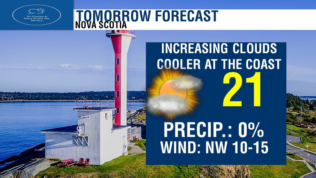 Tomorrow, We'll see increasing clouds in the South from the Valley to Yarmouth, Sunshine north. Much warmer! temperatures of 14 to 18 in the warmest spots inland. coolest near the water and over Northern Nova Scotia. Westerly and North-Westerly winds light. 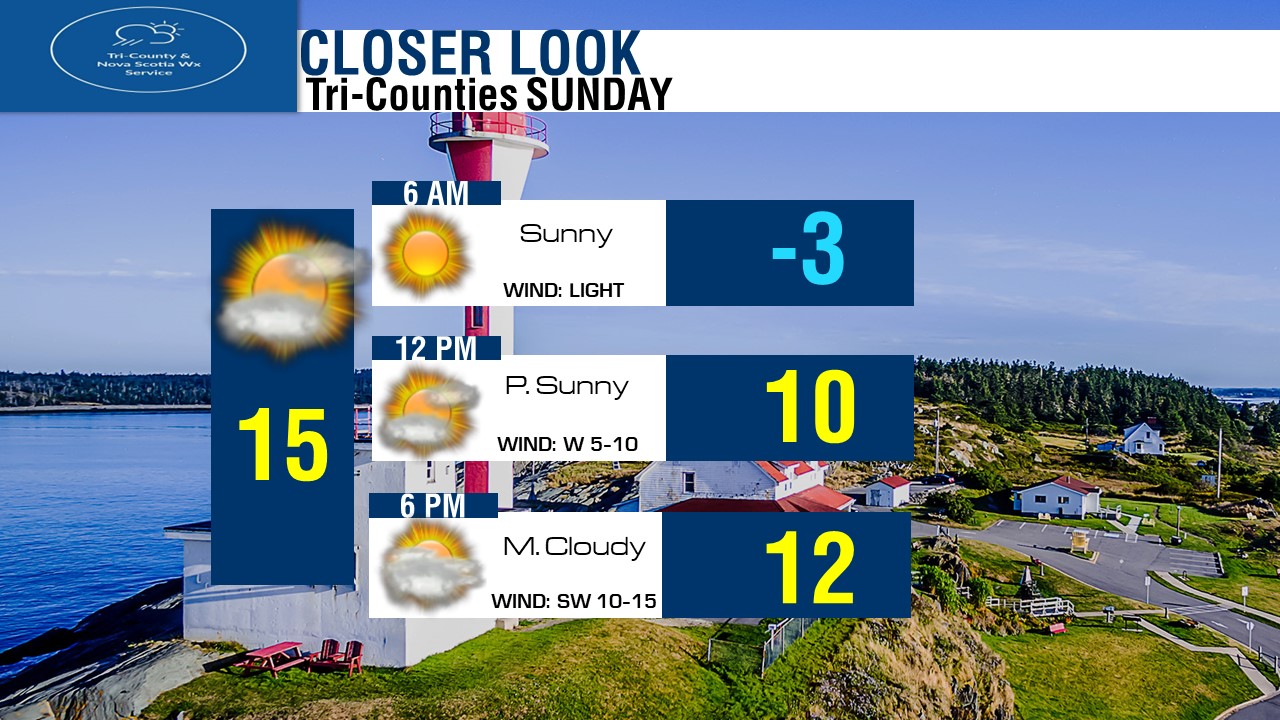 If you have plans in the Tri-Counties tomorrow, here is how things look to plan out weather wise! Looking at full sunshine to start, another cold morning near or below freezing. We'll quickly climb to near 10 by noon, with increasing clouds and Westerly light winds. We'll see lot's of clouds by Supper time, temperatures near 12 degrees. Highs in the Tri-Counties will reach around 15 tomorrow! Looking at the Regional 3 Day Forecast.
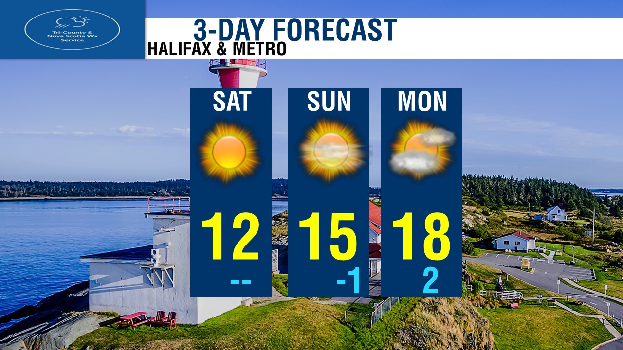
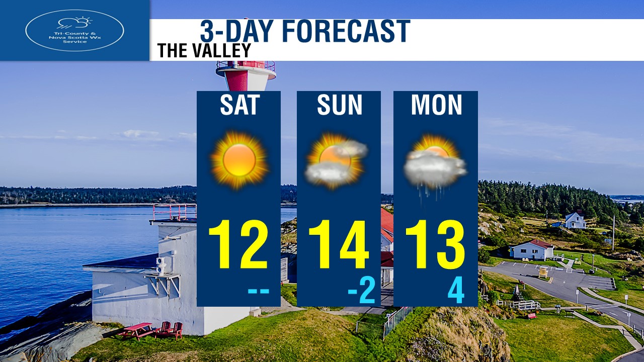
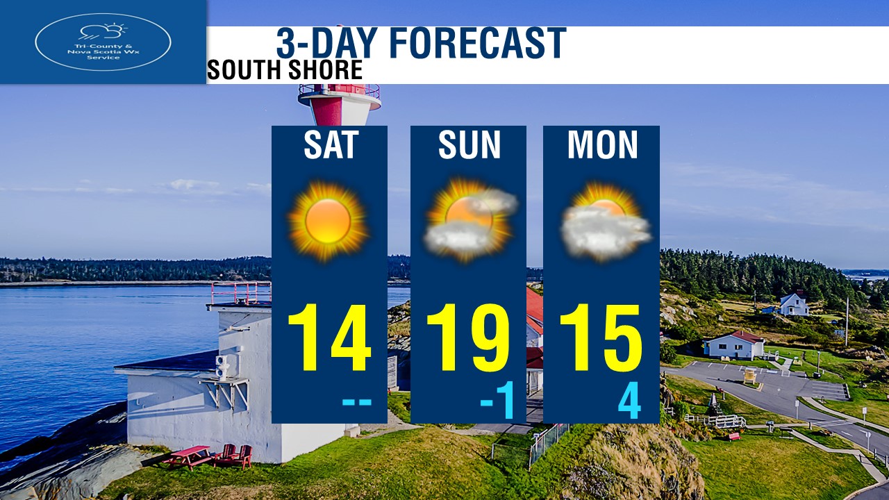
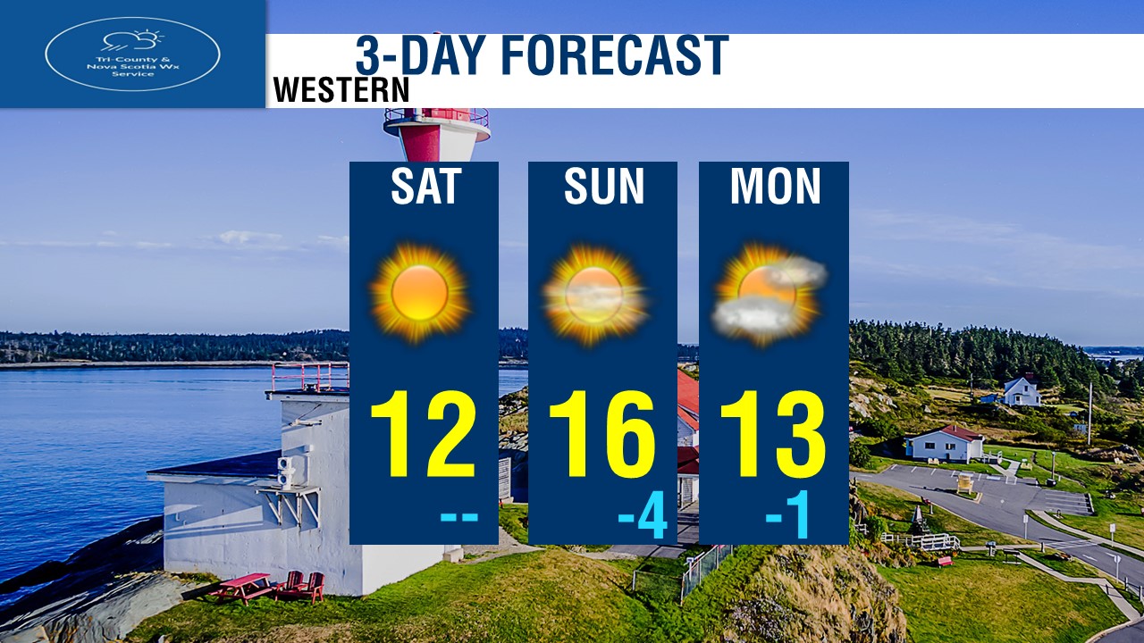
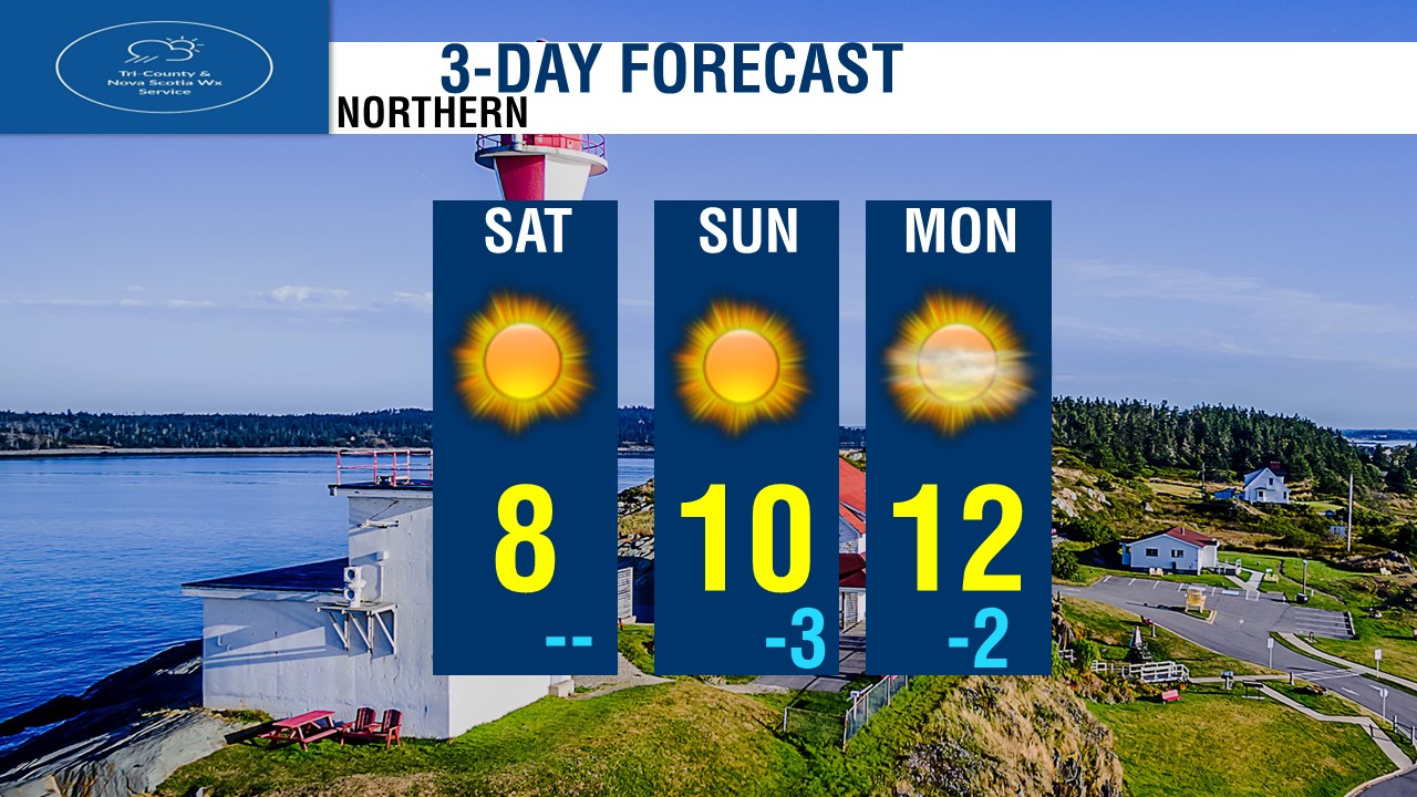
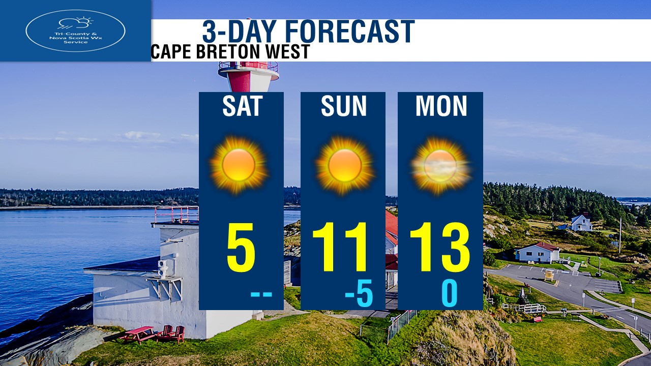
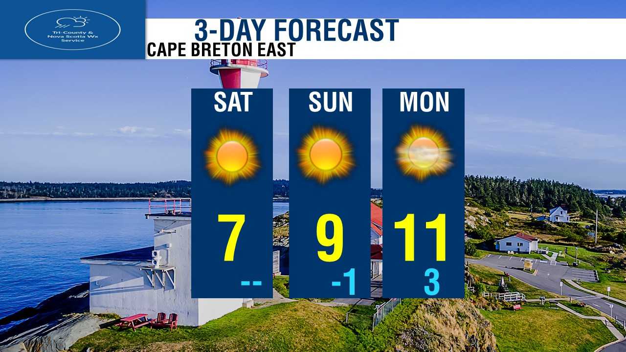
Starting with Halifax & Metro, Looking at sunshine Today and Tomorrow, increasing clouds on Monday. Temperatures of 12 today to 18 on Monday. For The Valley, looking at Sunshine today, Clouds on Sunday, and a chance of showers on Monday. Temperatures of 12 to 14 degrees. For Tri-Counties, Sunshine today and tomorrow, showers on Monday. Highs of 13 to 15 degrees. For South Shore, Sunshine today, Tomorrow and Monday with increasing clouds. Temperatures warming up nicely! 14 today, Balmy 19 Tomorrow! and slightly cooler day on Monday at 15 degrees. For Western, Sunshine today, increasing clouds Sunday and Monday. Highs of 12 today, up to 16 Tomorrow and 13 on Monday. For Northern, Lot's of sunshine all 3 days! Saturday, Sunday and Monday. Cool day today highs only in the upper single digits. we'll be near 10 Tomorrow and 12 on Monday. For Cape Breton West, Sunshine all 3 days! A cold day today with highs only near 5, we'll warm up a lot by tomorrow, highs near 11! and 13 on Monday. For Cape Breton East, Sunshine all 3 days, a cool wind will keep temperatures cool today and tomorrow in the single digits with highs of 7 to 9 degrees, up to 11 by Monday. Winter Storm Donavan brings Wintry mess Tonight Wintry weather continues over most of the province this evening, and will only continue into tonight and the early hours of Sunday Morning New Year's Eve. The system is the remnants of Winter Storm Donavan, and is located off the coast of Yarmouth. The systems will depart by tomorrow morning for most, except still be over Northern NS by tomorrow near noon. 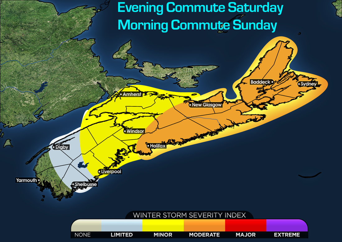 For the Evening Commute this evening and the commute tomorrow morning, looking at a WSI generally in the moderate category for Halifax, Northern NS and Cape Breton. This where we will see the highest snowfall amounts, some mixing of ice pellets and Freezing Rain and gusty winds, all this will give for hazardous travel and will likely lead to some travel disruptions. In Western NS, The South Shore, Eastern parts of the Valley the impacts will be minor, where only a small snowfall and some ice will lead to some minor travel disruptions. In Digby and Shelburne, as well as Western parts of the valley, looking at Very limited activity, very little snowfall, and mostly rain will cause very little to no impacts. but some slick roads is likely, but no travel disruptions. 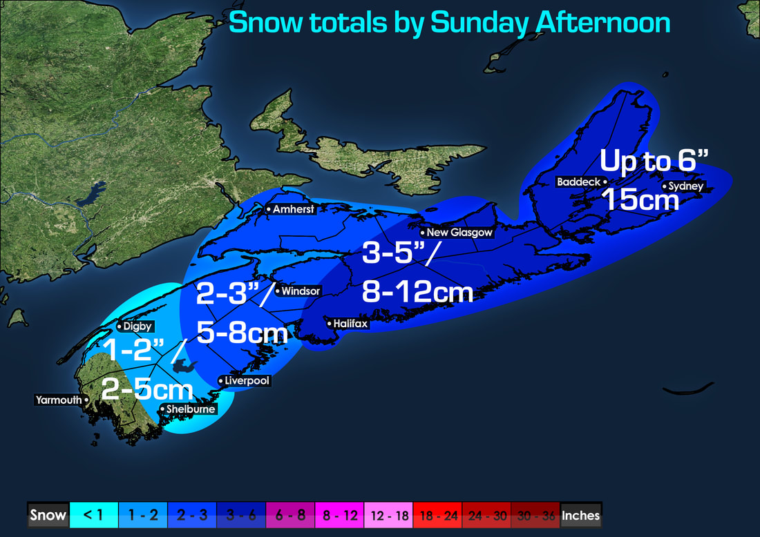 Snowfall amounts are generally light for many for those living south of Halifax, where amounts of only a few inches is expected, around 1-3" or 2 to 8cm. However a more higher snowfall expected over Halifax, New Glasgow, Baddeck to Sydney. where between 8 and 16cm can fall, highest near Cape Breton. New Year's Forecast Is Dry And Turning Colder Looking at the FutureCAST taking us into New Year's and through mid week. We'll see a high pressure keeping us dry Sunday, Monday, Tuesday and even Wednesday. although lot's of clouds, it will be dry! but cold! 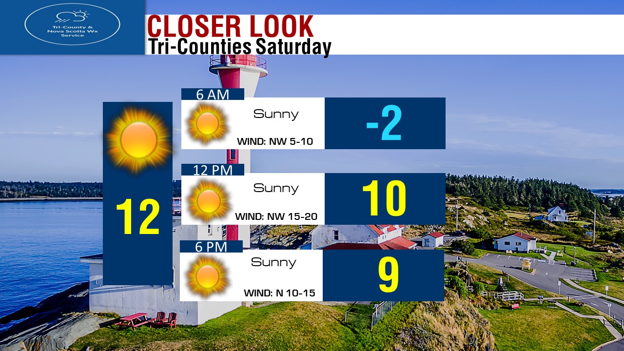 Forecast for tomorrow in Halifax will be cold and snowy to start, but we'll gradually get nicer through the day, but still chilly! Still Watching For Possible Major Nor'Easter Late In The Week. The Next Nor'easter will arrive late in the week, either Thursday or Friday. We have a cold core storm system over the Great Lakes, and our Warm Tropical Low over the Gulf of Mexico. That cold system will swing North East, meanwhile the Warm system heads South & East towards the cold system, this timing is on Wednesday Afternoon. 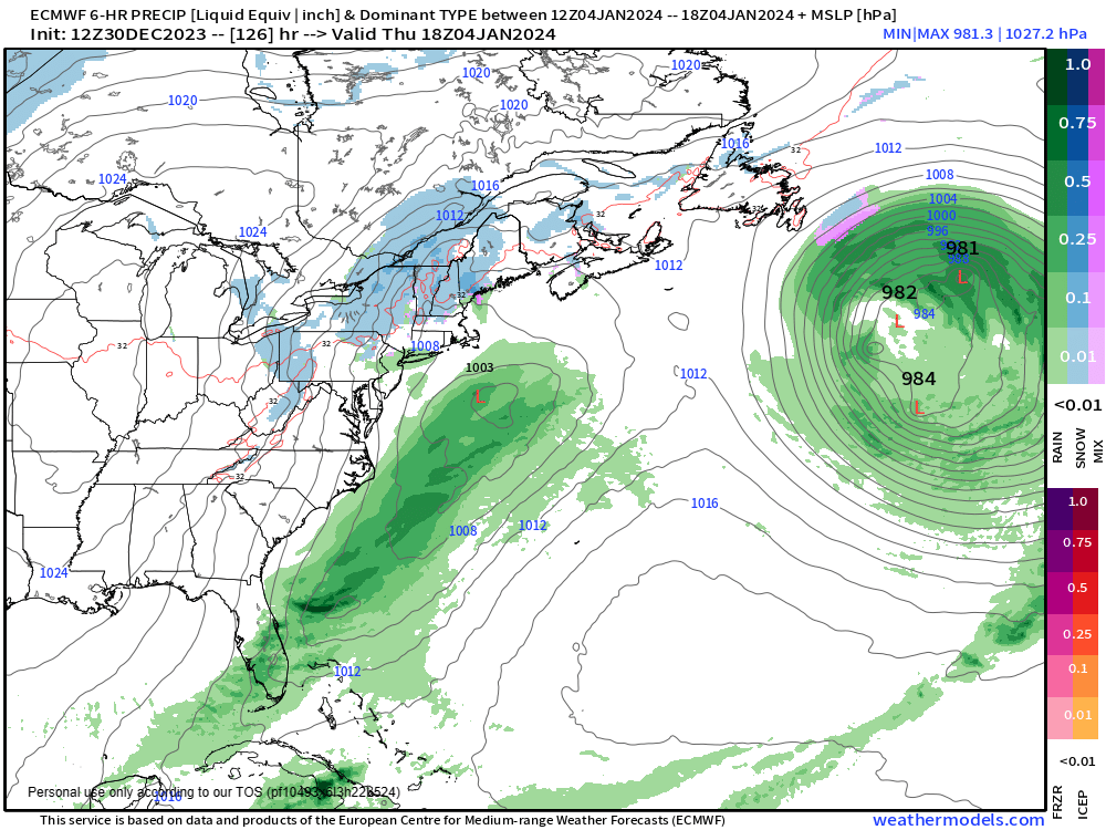 By Thursday Afternoon, the cold system is now over the New Hampshire/Quebec Border, and the warm system is developing more offshore just off Cape Cod. 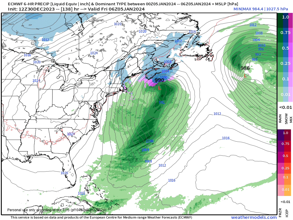 By Thursday Overnight into Friday Morning, around 2 to 3am. we'll see the both systems merge to form a stronger system, winds will increase, but snow at times heavy will cover the province Thursday night and continue into Friday. 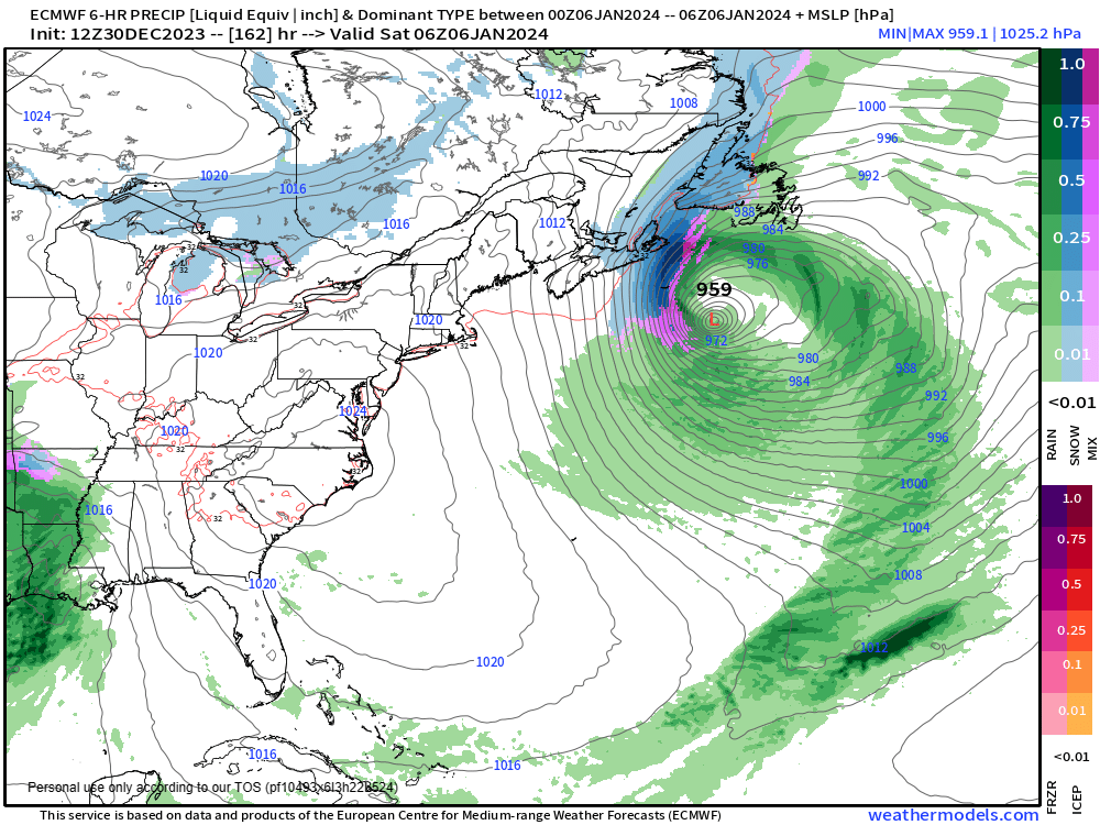 By Friday Overnight into Saturday, the nor'easter is very strong with a pressure at 959mb just off the South East of Sable Island. Although snow will be done with over Halifax and folks South of the city. there will still be very gusty winds causing blowing and drifting snow. For Cape Breton, we will see Big blizzard conditions continue with very strong winds and very heavy snow. 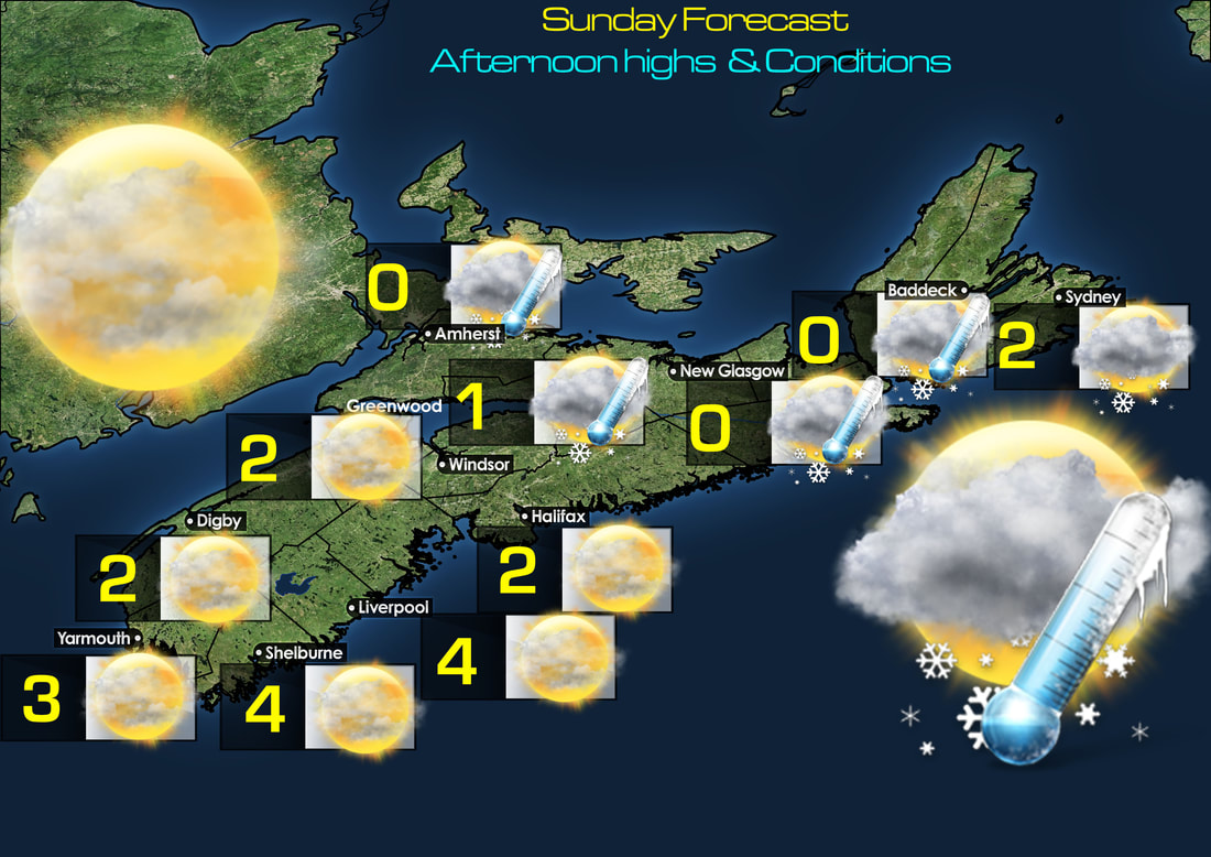 Tomorrow's Forecast for the last day of 2023, we'll see Partly cloudy skies, except flurries North. Highs between 0 and 4 degrees. 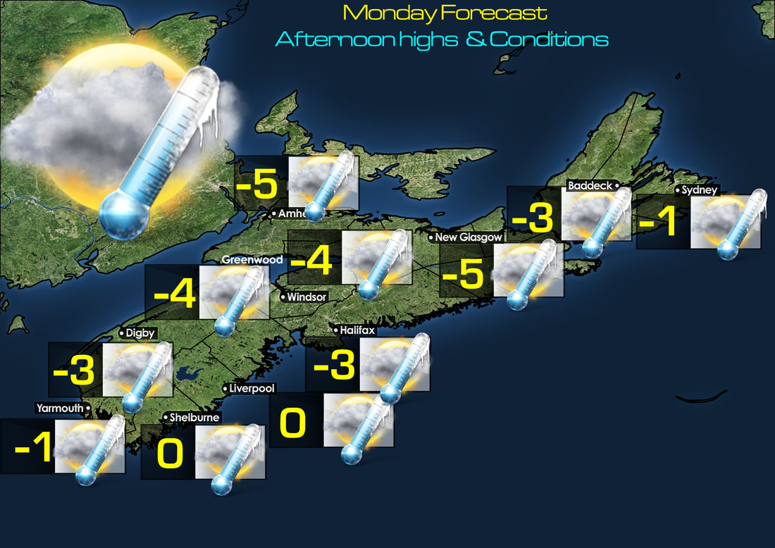 New Year's Day Full day of 2024, we'll see Mostly Cloudy skies and cold air! highs of 0 to -5. 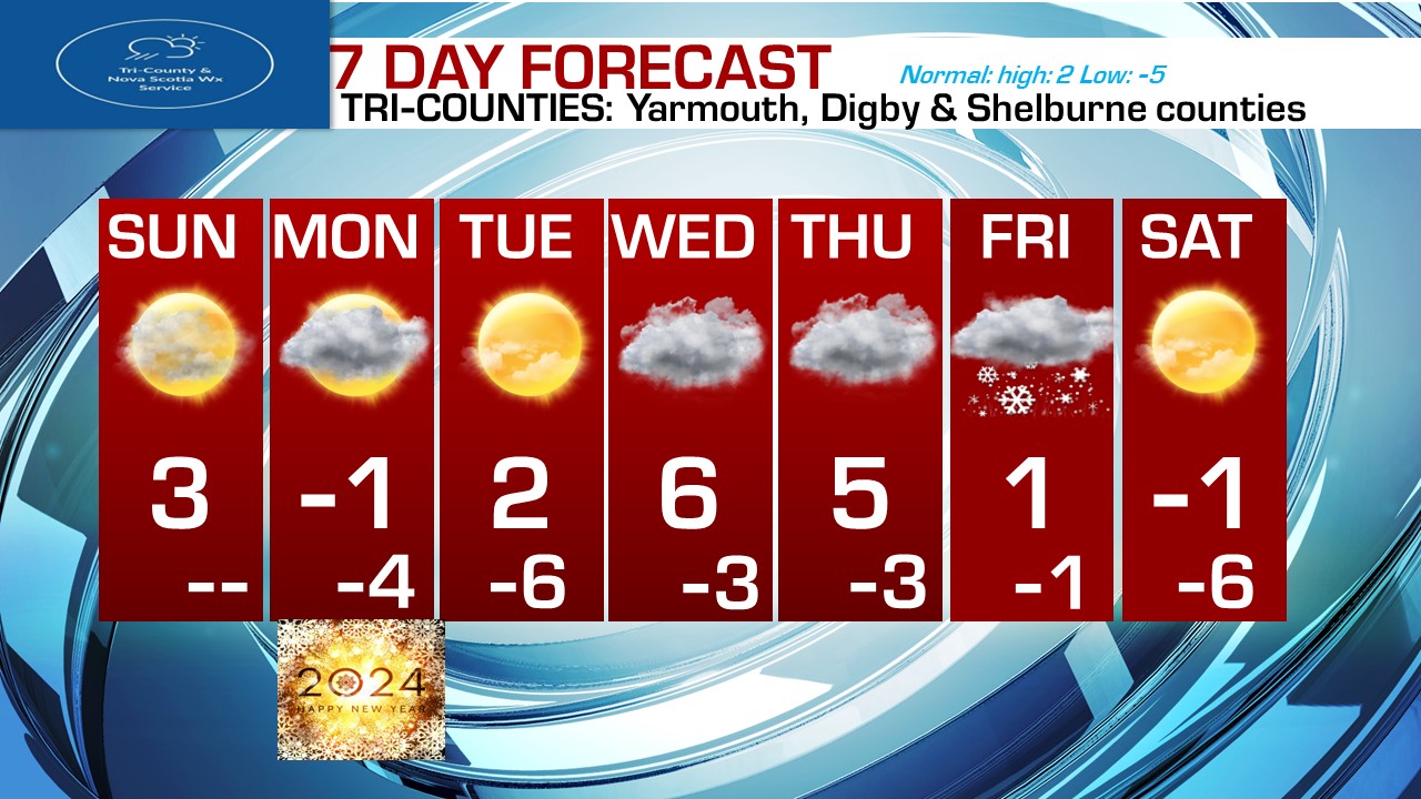 Looking at 7 day forecast, we'll see dry weather Sunday, Monday, Tuesday, Wednesday, and Thursday. We'll see highs not bad Tomorrow near 3 or 4 degrees. we'll be a bit chilly to cold on Monday, at -1. Lot's of sunshine on Tuesday and 2 above zero, We'll see milder temperatures on Wednesday and Thursday with highs near 5 and 6.
By Friday, we're watching that major Nor'easter. Sunshine for the first weekend of 2024! highs to be near normal! near -1. Winter Storm, Winter Wx Advisories & High Wind alertsWe'll start this quick late evening update with the latest on the alerts from here at TCWS. We have Winter Storm warnings, Winter Weather Advisories and High Wind warnings all in place for Northern NS and Cape Breton for Tonight into Tomorrow. Winter Storm Warning:Under the Winter storm warning is all of Western Cape Breton, which includes Inverness and Victoria County. In these areas, snowfall of up to 40cm in some places, and high winds of upwards of 60 to 70 km/h sustained with higher gusts to 100 km/h is expected. The heavy snow and high winds will create extreme hazardous travel conditions for the areas on Friday as well as Saturday. The high winds will cause near 0 visibility, and complete whiteout blizzard conditions at times. Conditions will improve by Saturday, with much nice weather in time for Christmas and beyond. Winter Wx AdvisoryNext we have the Winter Wx Advisory, this includes Northern NS for the counties of Antigonish, Guysborough and Pictou counties, as well as Eastern Cape Breton for Cape Breton county and Richmond county. Under this advisory, Minor snowfall accumulations, but high winds up to 100 km/h in gusts will create low visibility and slippery travel conditions in time for the Holiday weekend. Visibility will be reduced at times to near 0 under high wind gusts during snowfall. High Wind WarningLast but not least! we have the High Wind Warning, this is in place for Northern NS and all of Cape Breton. Under this alert, high winds will continue for the areas tonight, Friday and early Saturday. Sustained winds from the North West will be sustained 50 to 70 with higher gusts to 100 km/h. Winds will diminish starting tomorrow night. Winds at this intensity can bring down trees, especially where areas will see a foot or more of snow, and ice. along with downed power lines, creating further power outages, and minor wind damage to sidings and roof shingles. Province Wide Cold Again Tonight! If you're South of Halifax, you will be in for another cold night tonight! Air temperatures in those areas which include Tri-Counties, South Shore, The Valley, Halifax & Western NS will be anywhere in the range of -6 to -10 degrees, that does not include wind chill! The temperatures are more modest in Northern NS And Cape Breton, where lows will dip into the -5 to +1 range! Teeth Chattering Wind Chills Tonight Now with the -6 to -10 air temps, we also have very gusty winds, the winds will make it feel like -12 to -18 degrees C that is 8 to 0 degrees F. The Wind chills in the North where it will be milder, despite the high winds near 70 km/h sustained, will be milder at around -12 to -8 C that is 10 to 18 F. Warmer temperatures to return in time for Christmas If you don't like the cold, don't worry! because we're going to warm up, and sooner than you think! The very slow moving atmospheric river will be moving out on Saturday, and that means a blocking high has also moved out, this will be replaced by a blocking high pressure that will bring warm Christmas sunshine! Temperatures will be on the rise each day through at least the 27th of December, temperatures will be cold tomorrow near -3 or -4, but will gradually warm to near freezing on Saturday, and then shoot right up into the mid and upper 5's for Christmas and head for the low 10's on Boxing Day and stay there for a few days later. The biggest warmth will occur on Wednesday into Thursday of next week, thanks to a warm air advection, this will mean we will see a return to rain, not a heavy soaker. but a few showers on Wednesday will give way for a steadier light rain on Thursday, winds shouldn't be an issue at the moment either. New weather Pattern to take hold Currently we're under that stubborn non moving upper-level low trough north of Cape Breton, the good news is that a new pattern will take hold starting for the weekend! A building ridge will make way for a Bermuda high, this will bring us sunshine for Christmas and Boxing Day, but also very mild temperatures as a push of warm tropical air comes with a south east flow. Plan on highs for Christmas nearing or flirting with 10-degrees! however Northern NS, and Cape Breton will be much colder near freezing. The warmth holds off until after Boxing day in those regions when a front comes through, a warm front that will bring the return of rain but again the milder temperatures! where highs will again head back into the mid teens. Tomorrow forecast and temperatures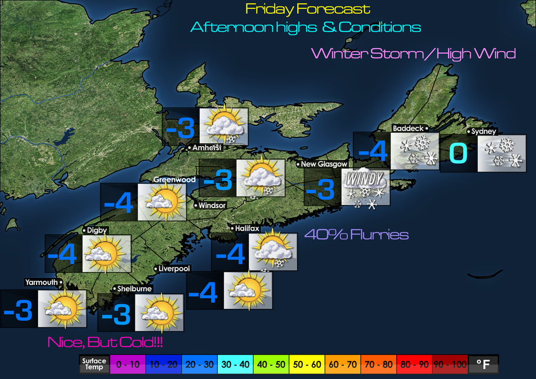 An overall quiet day tomorrow, except in Northern NS. but a cold one! highs around -3 to -4, except near freezing in Sydney. 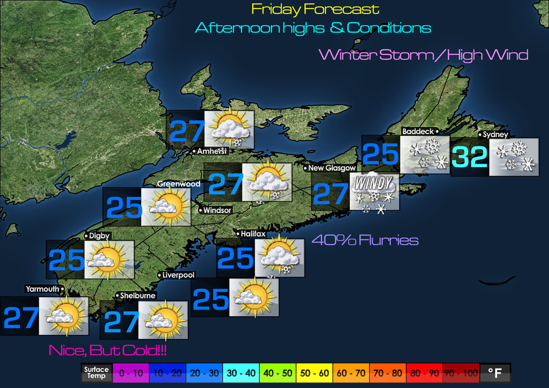 highs in F tomorrow, generally in the mid and upper 20's. 7 day forecastQuiet weather through Tuesday! with climbing temperatures each day, then a little showery by mid to late next week, but very mild into the 10's.
For Northern NS, Western and Cape Breton. snow continues tonight, and tomorrow. then temperatures will climb to the north shortly after Boxing Day. Good Morning! We are on storm team coverage this morning and all of today as we continue to monitor the progress of Hurrican Dorian.
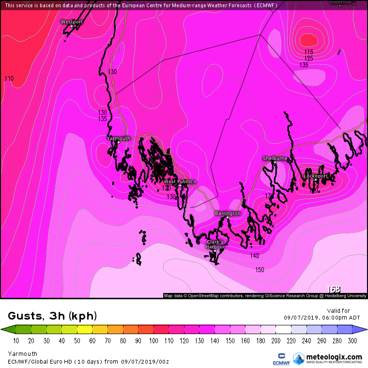
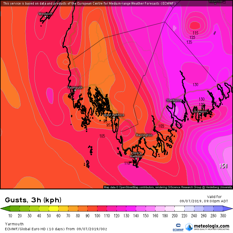
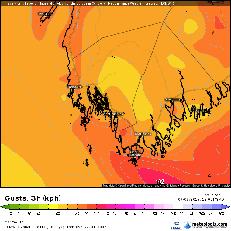
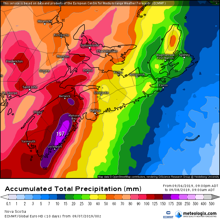
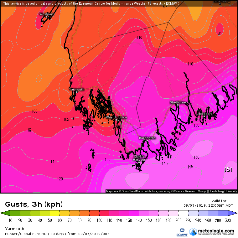
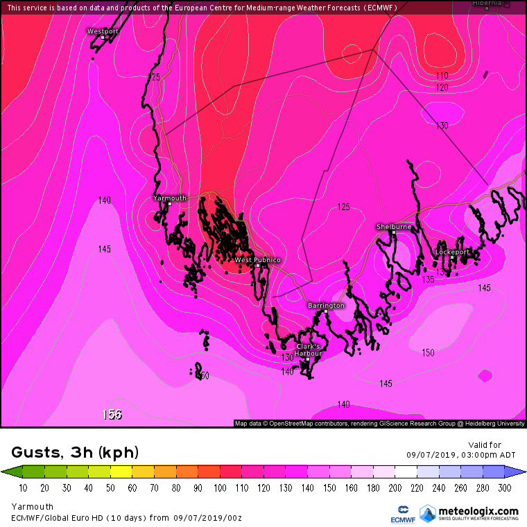
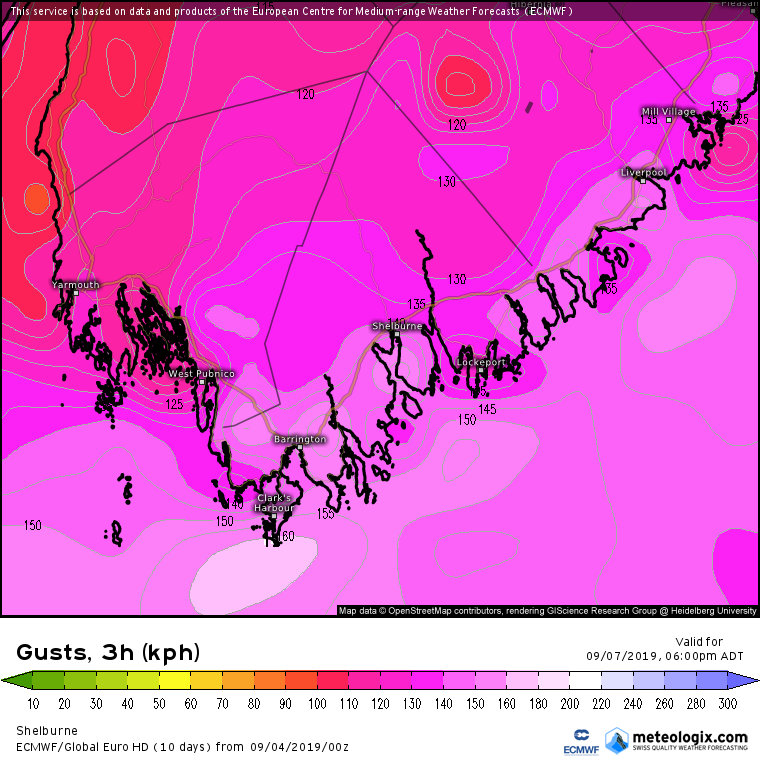
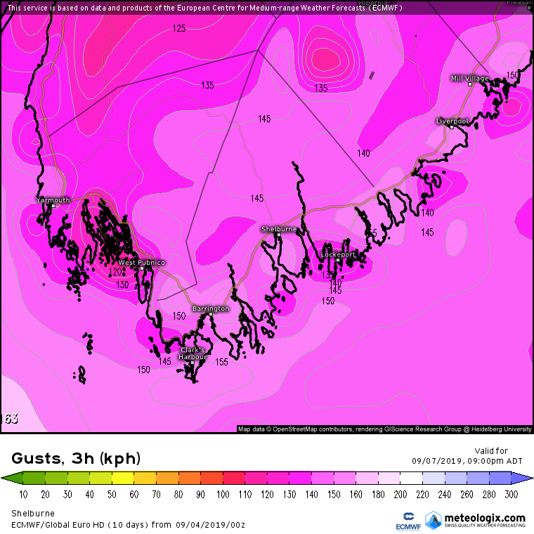
We have our 3 Storm Team forecasters James, Luke & Kirsten We’ll first go to James with the latest on Dorian Thanks Dustin, well as of 9am, Dorian is still a category 1 hurricane with winds of 40km/h still heading NE on the same track. So there has been no change in the track since yesterday afternoon, if it continues on this track, at the same rate it is at now, Dorian will make landfall later this evening, in about a little under 12 hours between Halifax and New Glasgow. Looking at the Satellite imagery of Dorian right now, can see that he is a fast mover, heading NE. The center of the storm is looking more impressive than what it was earlier this morning, the storm now not looking more of a hurricane because we are in the transition period where colder air wraps in the storm and she becomes a post-tropical system. Ok, let’s go to the Future WindCASTER. These are wind Gusts from noon to 6am tomorrow morning. So starting at noon, we see Gusts already approaching the 100 to 140km/h range. Highest in Shelburne area, Yarmouth in town will see a gust of 100-105 km/h, Digby gusting up to 80km/h. Fast forwarding now to 3pm: Digby now gusting to 120km/h which is Hurricane Force.. by 3pm, parts of the coast and along Brier Island a little stronger at 120-130km/h. Yarmouth county 125-130km/h in town which is Hurricane Force, coastal areas will be gusting higher at near 140km/h, but closer to the Hurricane at it’s nearest approach, Shelburne will see winds gusting 125 to 150km/h, especially near the coast. Now at 6pm: These are when the winds will be at there strongest! Digby gusting to 130km/h, Yarmouth at 135 km/h and Shelburne at 140km/h, there will be coastal areas reaching 150km/h. Check out those Gusts offshore though, 170km/h! By 9pm: Winds in Shelburne are still Gusting 100 to 140km/h, Yarmouth County still blowing at 80 to 100km/h and Digby at 120 to 140km/h By Midnight: winds are done at hurricane force, but Tropical Storm force winds continue well into Midnight, Gusting to 90km/h on the coast and 60 to 80 inland. By 3am: we’re down to only Tropical storm force winds of 80km/h. Now along with wind, is also the rain! And lot’s of it! For Yarmouth & Digby, plan on 90 to 130mm, with possibly higher amounts! Shelburne will see the most with up to 125 to 200mm! And now we go to Lucas who is in Tusket, riding out the storm.
Special 6am Update on Hurricane Dorian In this update: - Dorian Current information - Dorian Track - Dorian impacts - Dorian Rain & Wind time line/amounts. - Watches/Warnings - Tips on what to do to prepare for the Hurricane! Good early morning, We are now only a little under 48 hours before Dorian makes landfall in Nova Scotia, Here is the latest on Dorian.. ABOUT 15 MI...25 KM S OF CAPE LOOKOUT NORTH CAROLINA ABOUT 80 MI...130 KM SW OF CAPE HATTERAS NORTH CAROLINA MAXIMUM SUSTAINED WINDS...90 MPH...150 KM/H PRESENT MOVEMENT...NE OR 45 DEGREES AT 14 MPH...22 KM/H MINIMUM CENTRAL PRESSURE...956 MB...28.23 INCHES Hurricane Dorian's forward motion is northeast as it begins to encounter stronger shear which will contribute to a gradual weakening. This slow decrease in intensity will continue as the hurricane begins to race towards Atlantic Canada. No change from the previous forecast track which maintains a land-falling hurricane somewhere over Eastern Nova Scotia overnight Saturday. Dorian will begin extra-tropical transition Saturday evening over Nova Scotia, completing the process over the Eastern Gulf of St. Lawrence or Western Newfoundland early Sunday. Dorian will remain a very potent post-tropical system with hurricane or near hurricane force winds as it crosses Northern Newfoundland. Hurricane-force winds extend outward up to 60 miles (95 km) from the center and tropical-storm-force winds extend outward up to 220 miles (350 km) as the storm transitions into a post-tropical Storm with Hurricane force when it crosses over Eastern Nova Scotia, we will see the wind field expand. Impacts: As Dorian approaches closer and closer to the South shore, We will see extreme heavy rainfall, Brutal sustained damaging winds. Rain: At the moment, Latest model runs show rainfall of 100 to 150mm by Sunday afternoon in Yarmouth and Shelburne, in Digby there will be less heavy rain but still enough to cause flooding problems. Digby can see as much as 70 to 100mm by Sunday afternoon. Winds: the latest track and models are in a good agreement that Tropical Storm force winds of 70+km/h will occur with Hurricane force gusts of over 120+km/h, During the evening hours Saturday when Dorian will make it closest approach to the south shores, sustained winds could potentially reach Hurricane force and gusts between 150 and 180km/h. These winds will topple down large trees with foliage, cause extensive power outages that can last several days to even a few weeks, and other damage such as to roof shingles, windows, cars, etc. Waves: Waves of 5 to 10 meters are expected beginning early morning Saturday and continue well into Sunday. These large waves combined with heavy rain and storm surge will highly lead to severe coastal flooding and damage on the coastal communities. Rip Currents: Rip Currents are expected on the coast and persons in the area should use extreme caution near the water. Timeline & Amounts: Rainfall: Saturday 3am: Light showers and Drizzle in Yarmouth & Shelburne Saturday 6am: Moderate rain on the coast, Light rain inland in all 3 Tri-Counties Saturday 9am: Moderate to Heavy rain Saturday Noon: Moderate to Heavy rain Saturday 3pm: Very Heavy rain as Dorian makes it closest approach. Starts as early as 1-2pm in Shelburne. Saturday 6pm: Very heavy rain continues Saturday 9pm: Heaviest rain begins to exit as the storm crosses over the Eastern shores, still Moderate to Heavy rain. Midnight: Light rain in Digby, showers and drizzle in Yarmouth & Shelburne. Sunday 3am: Rain is done with. Amounts: Yarmouth County: 100-130mm Shelburne County: 100-150mm Digby County: 80-100mm Winds (Sustained): Saturday 6am: Yarmouth: East @ 20km/h Shelburne: East @ 20km/h, except 40-60km/h on the coast (Tropical Storm Force) Digby: East @ 20km/h Saturday 9am: Yarmouth: East @ 30km/h Shelburne: East @ 30km/h except up to 60km/h on the coast. Digby: East @ 30km/h Saturday Noon: Yarmouth: North East 50km/h, except 80km/h on the coast (Tropical Storm Force) Shelburne: North East 40km/h, except 60 to 90km/h on the coast (Tropical Storm Force) Digby: North East 30km/h Saturday 3pm: Yarmouth: NNE @ 50km/h except 85 km/h on the coast (Tropical Storm Force) Shelburne: NNE @ 50km/h except 85km/h on the coast (Tropical Storm Force) Digby: NNE @ 50km/h except 100km/h on Brier Island (Tropical Storm Force) Saturday 6pm: Yarmouth: NW @ 80km/h, except 110km/h on the coast (Tropical Storm Force) Shelburne: NW @ 60km/h, except 115km/h on the coast (Tropical Storm Force) Digby: NW @ 75km/h, except 100km/h on Brier Island. (Tropical Storm Force) Saturday 9pm: Yarmouth: NW @ 40km/h, except 70km/h on the coast. (Tropical Storm Force) Shelburne: NW @ 60km/h, except near 80km/h on the coast. (Tropical Storm Force) Digby: NW 60km/h Winds: (GUSTS) Saturday 6am: Yarmouth County: 40-60km/h Shelburne County: 50-70km/h (Tropical Storm Force) Digby County: 30km/h Saturday 9am: Yarmouth County: 50-70km/h (Tropical Storm Force) Shelburne County: 60-90km/h (Tropical Storm Force) Digby County: 40-50km/h (Tropical Storm Force) Saturday Noon: Yarmouth: 80-100km/h (Tropical Storm Force) Shelburne: 80-115km/h (Tropical Storm Force) Digby: 70-80km/h (Tropical Storm Force) Saturday 3pm: Yarmouth: 120-140km/h (Hurricane Force) Shelburne: 140-160km/h (Hurricane Force) Digby: 100-120km/h (Tropical Storm Force) Saturday 6pm: Yarmouth: 130-160km/h (Hurricane Force) Shelburne: 130-150km/h (Hurricane Force) Digby: 110-140km/h (Hurricane Force) Saturday 9pm: Yarmouth: 130-160km/h (Hurricane Force) Shelburne: 130-160km/h, except up to 180km/h near Clark’s Harbour.(Hurricane Force) Digby: 120-140km/h (Hurricane Force) Midnight: Yarmouth: 80-120km/h (Tropical Storm Force) Shelburne: 90-120km/h (Tropical Storm Force) Digby: 100-130km/h (Hurricane Force) We have several watches & warnings in effect! FLOOD WARNING WIND WARNING HURRICANE WATCH Flood Warning: Rainfall from Dorian is expected to dump as much as 100 and 150mm of rainfall combined with storm surge, large waves and pounding surf. Flooding is expected and heavy rainfall from Dorian can cause flash and coastal flooding. Wind Warning: Very High winds over 90km/h is expected from Hurricane Dorian Saturday and Saturday night. Hurricane Watch: Hurricane Conditions from a Hurricane is possible in the next 36 hours, Hurricane winds are 120+km/h, along with flooding rains, and storm surge or pounding waves. Here is some Hurricane Safety tips! In a **WATCH** (Which we are currently in) - Turn Refrigerator to the coldest setting to preserve food longer - Keep your car fueled. - Have plenty of emergency supplies stored, such as canned food,batteries, propane for a camp stoves, extra money, etc. - Fill water bottles and the bathtub with water. - Review Family evacuation plans - Bring pets indoors!!! - Bring Outdoor objects inside the house or garage. - Make sure medical supplies are available. If a WARNING is issued: - Board up windows and garage - Unplug appliances - Be prepared for evacuations ( mainly coastal areas) Next update at 5pm. Wednesday Morning update for September 4, 2019 In this update: - Latest on Dorian, Fernand, TD8 and Invest 92-L - The very dangerous threat that Dorian has on the Tri-Counties for the weekend… 1. Latest on the Tropics: - Dorian: ABOUT 105 MI...175 KM E OF DAYTONA BEACH FLORIDA MAXIMUM SUSTAINED WINDS...105 MPH...165 KM/H PRESENT MOVEMENT...NNW OR 340 DEGREES AT 8 MPH...13 KM/H MINIMUM CENTRAL PRESSURE...961 MB...28.38 INCHES Dorian continues to weaken and move ever so slowly, and is expected to near the Florida/Georgia border later tonight, then make a very near landfall in the Carolinas Tomorrow, and then gather steam and head for us next by the weekend. - Fernand:ABOUT 90 MI...145 KM SE OF LA PESCA MEXICO ABOUT 95 MI...150 KM NE OF TAMPICO MEXICO MAXIMUM SUSTAINED WINDS...50 MPH...85 KM/H PRESENT MOVEMENT...W OR 265 DEGREES AT 3 MPH...6 KM/H MINIMUM CENTRAL PRESSURE...1000 MB...29.53 INCHES Tropical Storm Fernand is a weak Tropical Storm, that is currently bringing Tropical Storm conditions to the coast of Mexico, Fernand is Moving West at 6 km/h with max wind speeds of 50 mph or 85 km/h. Fernand is expected to make landfall very late tonight in Mexico and then weaken to a Tropical Depression afterwards through the day tomorrow and be ripped apart from mountains on Friday. - Tropical Depression # 8: ABOUT 615 MI...995 KM WNW OF THE CABO VERDE ISLANDS MAXIMUM SUSTAINED WINDS...35 MPH...55 KM/H PRESENT MOVEMENT...NW OR 320 DEGREES AT 8 MPH...13 KM/H MINIMUM CENTRAL PRESSURE...1006 MB...29.71 INCHES Tropical Depression # 8 is expected to become Tropical Storm Gabrielle later today, as it heads for the open waters of the Mid Atlantic, This storm could pose a possible threat to our neck of the woods by middle of next week. PS: Latest data as of 5:30am, as I am writing this… shows that TD8 is Now TS Gabrielle, next update from the NHC should confirm that! - Invest 92-L: A trough of low pressure, located just east of Bermuda, is producing disorganized showers and thunderstorms. Some development of this disturbance is possible, and a tropical depression could form during the next couple of days as the disturbance moves northeastward, away from Bermuda. Afterward, upper-level winds are forecast to become less favorable for tropical cyclone formation. Interests in Bermuda should monitor the progress of this system, and areas of heavy rainfall are likely. * Formation chance through 48 hours...medium...50 percent. * Formation chance through 5 days...medium...50 percent. - Invest 94-L: A tropical wave is forecast to emerge over the far eastern tropical Atlantic between Africa and the Cabo Verde Islands later today. Environmental conditions are forecast to be conducive for development, and a tropical depression is likely to form late this week or over the weekend while the system moves westward to west-northwestward. * Formation chance through 48 hours...low...near 0 percent. * Formation chance through 5 days...high...70 percent.
We have been monitoring Dorian for quite sometime now, and for much of the time the models have been pretty consistent, and they still are! There is some disagreement on timing, strength and a slight difference in track.. But there is a few things we know! - We know that Dorian WILL have a big impact on the province. - We know the timing will be very early Saturday morning or afternoon. - We know that Dorian will spread very heavy rain and Tropical Storm force winds to the Tri-Counties. Dorian will arrive near the Tri-Counties on Early Saturday, and most of the Global models have it very close, so close in fact that it is still debatable if we will see Hurricane Force Conditions! Which are winds of 120km/h or greater. There are 4 top Hurricane weather models, the ECMWF, GFS, HMON & UKMO. The ECMWF being the most reliable and accurate model in the world, followed by the GFS.. The ECMWF,HMON, ICON models show a very close pass to the south of Shelburne by Saturday morning, close enough to bring Hurricane conditions. Meanwhile, the GFS, UKMO, GEM, ACCESS-G and APREGE models puts it still further out, however close enough to bring Tropical Storm conditions. Dorian is currently being steered by 2 Big ridges of High pressure, one over the Atlantic, and another in the Southern states. Meanwhile, there is a cold front that is over the Great lakes that is heading Eastward and is the same cold front that will bring us some rain for later tonight into Thursday.. This front could play a role in where Dorian goes, if the front can stall a little then maybe it could be just in time to grab Dorian and push it further out, just enough to give us a break from the Strongest winds. We will have to still deal with flooding rain, and Tropical Storm wind Gusts but the Hurricane force will be far enough offshore. If the front passes sooner than expected and is moving faster than Dorian, Dorian will miss it, and eventually will come up farther north and much closer that thought which will lead to Hurricane conditions. In my honest opinion, It is looking very likely that the worst case scenario will happen.. The cold front will be to quick, and Dorian won’t have time to catch up to it because she is simply just to slow! Along with the fact that models continue to trend Westward, and the ECMWF is on board with it, for this update the TCWS will be following the track and conditions close to what the ECMWF and ICON model consensus are predicting. So let’s start with Rainfall! With the timing first. Saturday 3am: Drizzle or showers starts in the Very southern tip of Shelburne, ( Clarks Harbor, Barrington, etc) Saturday 6am: Rain spreads into the entire county of Yarmouth & Shelburne as some light to moderate rain, Extreme southern tip of Digby starts seeing some Drizzle. Saturday 9am: Moderate rain arrives in Yarmouth and Shelburne, light rain spreads into the rest of Digby. Saturday Noon: Rain becomes heavier in all 3 Tri-Counties. Saturday 3pm: Getting near the center! Rain becomes a bit more heavier, rain rates of 15-20mm/3hrs. Saturday 6pm: Dorian unleashes her Tropical drenching downpours, this is the very heavy rain!! rain rates now in Shelburne at this hour would be 30 to 50mm/3hr, a little less in Yarmouth and Digby at 15-20mm/3hr Saturday 9pm: Heaviest rain arrives! Shelburne being hardest hit, with 60-70mm per 3 hrs! or 20mm per hour! Still heavy rain rates in Yarmouth and Digby. Sunday 12am: Heaviest rain moves out, but still raining fairly heavy. Sunday 3am: Rain becomes lighter, almost like a light to moderate rainfall. Sunday 6am: Tapers to light showers and drizzle Sunday 9am: Clears out. So the rain lasts for a long time! And very heavy too.. and this being a big Tropical System, it is no doubt that we will get a lot! So how much? Digby County: 80 to 100mm Yarmouth County: 90-110mm, However for towns near West Pubnico and East of there that is close to the border of Shelburne, rainfall amounts of 130-160mm is very likely. Shelburne: 115-160mm, heaviest in town of Shelburne, clark’s Harbour and Barrington. Now the rain is big, but the winds will be the worst of them all! Very damaging winds… Starting us off at 9am on Saturday: Sustained winds of 30 to 40 on the coast, 15-25 inland, Gusts of 50-70km/h on the coast and 30-40 inland. Saturday @ Noon: Sustained winds at the coast clock 60 km/h, nearing tropical Storm force, Inland areas between 20-30km/h. Gusts on the coast reach 70 to 90 km/h, easily Tropical Storm force. Saturday @ 3pm: Sustained winds at the coast now exceeding tropical Storm force at 70-90km/h, the threshold for damage.. Inland, sustained winds are at 40km/h. Gusts at the coast are between 100 and 120 km/h, nearing Hurricane Strength, while Inland Gusts are 80 to 100km/h, enough to cause damage.. Saturday @ 6pm: Winds now reach 40-60km/h sustained inland, while the coast now have sustained wind speeds of 80 to 110 km/h! Strong tropical Storm force, these winds are past damage criteria, the Gusts will be much higher as the storm nears. Gusts on the coast at this hour, 130 to 160km/h! Hurricane force. Inland Gusts will be 100 to 120km/h. Saturday @ 9pm: This is when Dorian is just near the doorsteps of Shelburne! This is the worst of the storm for rain, wind and storm surge! Winds Sustained on the coast are now at 100+km/h, Inland sustained winds are over 60km/h, Tropical Storm conditions. Gusts will be at there strongest. Coastal Gusts at this hour will be 140 to 170km/h, Inland Gusts will be exceeding 140km/h as well and these are Category 1 hurricane force winds. So With winds Sustained near 100 on the coast and Gusts as high as 150km/h inland and the coast… what kind of Damage can we expect? This storm when at it’s nearest approach will likely still be a Category 1 Hurricane with 80 M.P.H winds, some of that wind field may enter Shelburne county. However,Hurricane Wind Gusts can be felt far inland into Yarmouth county at near 150km/h. What will be worst is the 100+ winds will persist for 6+ hours. Category Sustained Winds Types of Damage Due to Hurricane Winds 1 74-95 mph 64-82 kt 119-153 km/h Very dangerous winds will produce some damage: Well-constructed frame homes could have damage to roof, shingles, vinyl siding and gutters. Large branches of trees will snap and shallowly rooted trees may be toppled. Extensive damage to power lines and poles likely will result in power outages that could last a few to several days. 2 96-110 mph 83-95 kt 154-177 km/h Extremely dangerous winds will cause extensive damage: Well-constructed frame homes could sustain major roof and siding damage. Many shallowly rooted trees will be snapped or uprooted and block numerous roads. Near-total power loss is expected with outages that could last from several days to weeks. 3 (major) 111-129 mph 96-112 kt 178-208 km/h Devastating damage will occur: Well-built framed homes may incur major damage or removal of roof decking and gable ends. Many trees will be snapped or uprooted, blocking numerous roads. Electricity and water will be unavailable for several days to weeks after the storm passes. 4 (major) 130-156 mph 113-136 kt 209-251 km/h Catastrophic damage will occur: Well-built framed homes can sustain severe damage with loss of most of the roof structure and/or some exterior walls. Most trees will be snapped or uprooted and power poles downed. Fallen trees and power poles will isolate residential areas. Power outages will last weeks to possibly months. Most of the area will be uninhabitable for weeks or months. 5 (major) 157 mph or higher 137 kt or higher 252 km/h or higher Catastrophic damage will occur: A high percentage of framed homes will be destroyed, with total roof failure and wall collapse. Fallen trees and power poles will isolate residential areas. Power outages will last for weeks to possibly months. Most of the area will be uninhabitable for weeks or months. Next Update is at noon! Which will have more on the rain tonight and your full forecast! Along with updates on the Tropics! ~James Tuesday Early Morning Update- September 3, 2019
Good Taco Tuesday Morning ya’ll! On Satellite and Radar, we have a band of clouds, and some rain showers now moving away from the Tri-Counties. This rain from a weak cold front will continue to spread northward across the province today, can’t rule out a few showers or rumble of thunder this morning. But I do think we are done with the rain! Highs today will get into the low 20’s once again, 21 in Digby, 23 in Yarmouth & Shelburne, could even be a few spots touching 24. Dew points today are in the 17 to 19 degree range, so the Muggies are back, it’s going to feel a bit sticky at the coast, but inland areas will feel a bit uncomfortable. Frizz factor today is Frizzy! Sorry ladies! Skies will be mostly clear tonight, but high dew point temperatures, and fog will help keep the overnight lows a bit warm. Lows of 14 to 17 tonight. Tomorrow, we see more sunny skies thanks to a building ridge. Highs of 22 to 24 degrees, cooler on the coast. Dew point temperatures will be 16 to 18 so slightly lower than today, so you might notice a little difference in the air tomorrow, should be slightly less humid, but still in the sticky to uncomfortable range. Late Tomorrow night into Thursday afternoon, there is another weak front that will pass through to give us some more light showers. These will be more widespread in the overnight hours, by morning on Thursday it will be very spotty and just some light drizzle. Could pick up a good 5-10mm, Speaking of Thursday… it’s the First day of School! School Bell Forecast looks like this: 7am: Clouds & Drizzle. Temperatures of 16 to 19 degrees. Noon: Mostly Cloudy, Temperatures of 18 to 23 degrees. Warmest in Shelburne, coolest in Digby. 3pm: Partly Sunny and Temperatures of 20 to 24 degrees. To the tropics now, Hurricane Dorian, continues to refuse to budge, but has weaken some more and is now a Category 3 hurricane with 120 M.P.H. winds, He could be a Category 2 by Tomorrow morning at this rate. The Grand Bahama Islands continue to get pummeled by Dorian this morning. Dorian continues to have a track that will curve it up the coast nearing the Carolinas by Thursday and then gathering speed as it heads near our province in time for the weekend, Landfall looks to be somewhere in Cape Breton, however the storm will be so large and very close that here in the Tri-Counties, we could be feeling very strong Tropical Storm force conditions and perhaps some hurricane force conditions near Shelburne. Rainfall of 80 to 150mm is possible on Saturday, along with winds as high as 70 to 100 km/h sustained and gusts over 140km/h in Shelburne. Invest 91-L continues to show signs of organization, and could form into Tropical Depression # 6 later today, if not maybe even Tropical Storm Fernand. This system looks to bring heavy rain and Gusty winds to the Cape Verde Islands, and then out into the open waters, this system has no threat to us. Invest 92-L is gathering some organization, could become a Tropical Depression by end of the week. This system looks to bring some unsettled weather to Bermuda, but looks to remain far in the Atlantic to not bother any landmass. Invest 93-L continues to show Organization, and a Tropical Depression # 7 or Tropical Storm Gabrielle could form later today or Tomorrow as it heads for the Gulf of Mexico and into Mexico, this system will have no impact what so ever in Canada. Here now is your forecast For today, Morning showers and perhaps a thunder shower then clearing near noon. Winds NW light. Highs of 21 in Digby to 24 in Shelburne and 23 in Yarmouth, Cooler on parts of the coast. Tonight, clearing skies. Fog patches developing near midnight. Winds light from the North then North East near midnight. Lows of 14 to 17. Tomorrow, Wall to wall sunshine, morning fog patches. Less humid! Winds South East in the morning becoming Southerly or South Westerly in the afternoon at 15 km/h with Gusts to 30 km/h. highs of 22 to 24 inland, except cooler on the coast. That is your Morning forecast for TCWS. Have a great Tuesday! TCWS 11pm Evening update:
In this Update: * Latest on Dorian & the track * Dorian potential threat for here in the Tri-Counties * Invest 91,92 & 93-L * Timing and amounts of the rainfall for tonight into tomorrow * Sneak peak at Thursday’s back to school forecast * 7 day forecasts DORIAN, TRACK AND POTENTIAL IMPACTS IN THE TRI-COUNTIES: Dorian as of 8pm: ABOUT 30 MI...55 KM NE OF FREEPORT GRAND BAHAMA ISLAND ABOUT 105 MI...170 KM E OF WEST PALM BEACH FLORIDA MAXIMUM SUSTAINED WINDS...145 MPH...230 KM/H PRESENT MOVEMENT...STATIONARY MINIMUM CENTRAL PRESSURE...941 MB...27.79 INCHES Dorian is still a very dangerous storm that continues to pound the Grand Bahama Island as a Category 4 hurricane. Dorian remains an impressive hurricane in satellite imagery. Recent radar and aircraft observations are again showing signs of a concentric eyewall structure which might be one of the factors that has led to a decrease in the peak winds and a small expansion of the wind field. An Air Force Reserve Hurricane Hunter aircraft reported peak flight-level winds of 129 kt, SFMR winds of 121 kt, and a central pressure that has risen to 940 mb. Based on these observations, the initial wind speed has been set at 125 kt. Some additional decrease in wind speed is likely in the short term due due to a possible eyewall replacement and upwelling of cooler waters caused by the very slow motion of the hurricane. Although some additional slow weakening is forecast while the hurricane moves northward along the southeastern United States coastline due to increasing southwesterly shear, Dorian is forecast to remain a powerful hurricane during that time. Dorian has become nearly stationary this afternoon with the two most recent aircraft fixes showing essentially no motion. A slow westward to west-northwestward motion should resume overnight and continue into early Tuesday, with the eye and devastating winds only slowly pulling away from Grand Bahama Island. By Tuesday afternoon, Dorian should begin its much anticipated northwestward turn as a weakness becomes more pronounced in the subtropical ridge. Although the center of Dorian is forecast to move near, but parallel to, the Florida east coast, only a small deviation of the track toward the west would bring the core of the hurricane onshore. A broad mid- latitude trough should help turn Dorian northeastward by Wednesday night, and the track models show the center coming precariously close to the southeastern United States coast. The tracks from the 1200 UTC runs of the global models have remained fairly stable. It should then enter the Maritimes by Saturday morning, with the Tropical Storm force winds as early as Friday evening. The ECMWF, ICON, UKMO & GFS models have the storm just offshore, but very close to the province of Nova Scotia, while the GEM and few other models have it far offshore, the consensus is that Dorian will parallel Southern Nova Scotia on Saturday morning or afternoon, and for this update the TCWS will be going with the model consensus of the ECMWF,UKMO & ACCESS-G models, that put the storm offshore very dangerously close to land, then making landfall somewhere in Cape Breton by Saturday night or Sunday morning. DORIAN RAINFALL TRI-COUNTY FORECAST: ECMWF MODEL - 3am: Light showers or drizzle begin in Yarmouth & Shelburne county - 6am: Rain becomes heavier in Yarmouth and Shelburne with rain rates of 7-10mm/3hr, Digby to Halifax begins to see showers and drizzle. - 9am: Moderate to heavy rain begins to cover all 3 Tri-counties - Noon: Pockets of very heavy rain begins to move in the Yarmouth area. - 3pm to 9pm: Heaviest torrential rains arrive for all of the Tri-Counties with Shelburne the hardest hit, rain rates from 3pm to 9pm Saturday will be 40-80+mm/hr. - 9pm: heaviest rain pushes into Northern NS, rain tapers to showers inland of the Tri-Counties, and drizzle and showers for Yarmouth. - Midnight: Rain clears out. Total rainfall from 3am Saturday to midnight: Yarmouth County: 100-125mm Shelburne County: 115-180mm Digby County: 80-100mm Storm Surge of 5 to 10 meters above normal, and as much as 15 meters offshore,combined with 100+mm of rain will create serious flooding problems and beach erosion. DORIAN WIND TRI-COUNTY FORECAST: 6am: NE Sustained winds of 20-30km/h inland, 30-55 km/h on coast. Gusts of 50km/h inland, 70km/h on coast. ( Tropical Storm Force) 9am: NE Sustained winds of 30km/h inland, 40-60km/h on coast, Gusts of 60 km/h inland, Gust to 70-90km/h on coast. ( Tropical Storm Force) Noon: NE sustained 40km/h inland, 60-70km/h coast with Gusts of 70-90km/h inland, and 90-105 km/h on coast. ( Tropical Storm Force) 3pm: N Sustained winds of 40-50km/h inland, 60-80km/h Inland. Gusts of 80-100km/h in Yarmouth & Digby, except 100+ on the coast. Shelburne inland Gusts 110-130km/h, except up to 150km/h on the coast. ( Hurricane Force) 6pm: N Sustained winds of 40-60km/h, Gusts of 80-110km/h in Yarmouth, Digby county. And 110-140km/h in Shelburne. (Tropical Storm Force) to (Hurricane Force) in Shelburne. 9pm: NW Sustained winds of 30-40km/h, except 50-60km/h on the coast. Gusts of 80-100km/h, except 110+ over Northern Shelburne. (Tropical Storm Force) Midnight: NW Sustained winds of 20-30km/h except up to 40km/h on the coast. Gusts of 60-80km/h, except near 90km/h on extreme southern coast sections. (Tropical Storm Force) 3am: W Sustained winds of 10-20km/h with Gusts of 30-50km/h, except up to 60km/h on extreme southern coastal sections. ( Tropical Depression Force) Worst of the storm for Rain, Wind & Storm Surge combined will be between the hours of 3pm and 9pm Saturday Evening. Although the hurricane will track offshore, it’s Tropical Storm force Wind field will stretch far over the province and perhaps southern NB! Tropical Storm Force conditions are: 63 to 118 km/h Wind speeds (sustained or Gusts) Hurricane Dorian will be a Strong Category 1 or a weak Category 2 Hurricane when it reaches it’s closest approach to Southern shores. Category 1 winds are 120-153km/h Category 2 winds are 154-177km/h Dorian is expected to be having winds of 140 km/h sustained, with higher gusts to near 200km/h offshore. When it is near Shelburne. It is very highly likely that Hurricane Force Sustained And GUSTS will approach the Tri-Counties Saturday evening as a Category 1. Very dangerous winds will produce some damage: Well-constructed frame homes could have damage to roof, shingles, vinyl siding and gutters. Large branches of trees will snap and shallowly rooted trees may be toppled. Extensive damage to power lines and poles likely will result in power outages that could last a few to several days. If in the case, the storm comes closer and is a Category 2… Extremely dangerous winds will cause extensive damage: Well-constructed frame homes could sustain major roof and siding damage. Many shallowly rooted trees will be snapped or uprooted and block numerous roads. Near-total power loss is expected with outages that could last from several days to weeks. With all this in mind.. many people look back at Arthur, What is the difference between Arthur and Dorian? Arthur: Was a post tropical Storm when it tracked in the Bay of Fundy Dorian: Will pass offshore very close to Shelburne, as a extra- Tropical Hurricane or a full blown Hurricane with 85 mph winds. The track is very similar to Arthur, except it will stay offshore to the East instead of Bay of Fundy like Arthur did. This storm will be stronger compared to Arthur, and we very highly recommend that people prepare for this storm! There have only been 2 storms at category 2 strength that made landfall in NS, one is Juan that hit Halifax as a Cat 2 in 2003 with 100mph winds. But Ginny of ‘63 was a 110 mph hurricane when it made landfall in Yarmouth just a day before Halloween! That storm was only 1mph away from being classified a Category 3. Now Dorian is not the only system we are currently monitoring.. there is 3 others! Invest 91, 92 & 93-L. Invest 91-L: An elongated area of low pressure is located a few hundred miles west of the Cabo Verde Islands. Although this system is currently producing limited showers and thunderstorms, a tropical depression is expected to form during the next day or so while the system moves generally northwestward across the eastern tropical Atlantic Ocean. * Formation chance through 48 hours...high...80 percent. * Formation chance through 5 days...high...90 percent. Next name on the list is Fernand Invest 92-L: A trough of low pressure, located several hundred miles south-southeast of Bermuda, is producing disorganized showers and thunderstorms. Some gradual development of the disturbance is possible during the next couple of days. Afterward, upper-level winds are forecast to become less favorable for tropical cyclone formation. Interests in Bermuda should monitor the progress of this disturbance. * Formation chance through 48 hours...low...30 percent. * Formation chance through 5 days...medium...30 percent. Invest 93-L: An extensive area of showers and thunderstorms continues in association with an area of low pressure located over the south-central Gulf of Mexico. Environmental conditions appear conducive for additional development, and a tropical depression is likely to form during the next few days while the low moves slowly westward or west-southwestward toward the coast of Mexico. Interests along the northeast coast of Mexico should monitor the progress of this system. * Formation chance through 48 hours...medium...60 percent. * Formation chance through 5 days...high...70 percent. Next name after Fernand is Gabrielle None of these systems pose a threat to us here in Canada! Now closer to home in the near future, We do have some rain coming our way! A weak cold front is going to bring some rain to the Tri-Counties tonight into tomorrow. As of 10:30pm, some rain showers and drizzle are already approaching the Tri-Counties, this line of rain showers will progress through tonight, becoming a bit heavy at times with some embedded thunder-showers, Rain will begin to taper off tomorrow Afternoon. How much rain? Well not to much! 3 to 6mm, however there will be some pockets of heavier downpours that will bring rain amounts to 15 or more mm. Clears out for Wednesday with gorgeous sunshine and temperatures back into the low and mid-20’s! Back to school Thursday!!! Here is a sneak peak at what you can expect on Thursday as you head back to school. 7am: Mostly cloudy skies and 17*C Noon: Partly Sunny skies and 18*C 3pm: Partly Sunny skies and 20*C For Tonight: Showers, Drizzle and Fog with heavier showers and perhaps a rumble of thunder. Winds SE 15-30km/h. lows near 15. Tomorrow: Showers tapering off near noon then partly to mostly cloudy skies. Highs of 21 to 24 degrees, cooler on the coast. Winds SE 20 km/h. Tomorrow Night: Mostly clear skies, winds becoming light and lows of 12 to 14 degrees. Here now is your 7 day forecast! For Digby: Tuesday: Showers and 21* Wednesday: Sunshine and few clouds, 25* Thursday: Partly cloudy skies and 20* Friday: Mostly Sunny skies and 20* Saturday: Watching Dorian! Heavy rain, and strong winds. Highs of 13, temperatures falling to 12 in the afternoon. Sunday: Sunny skies and mild. Highs of 17* Monday: Sunny skies and cool. Highs of 15* For Yarmouth county: Tuesday: Showers and 23* Wednesday: Sunny skies and 24* Thursday: Partly sunny and 21* Friday: Mostly Sunny and 20* Saturday: Dorian! Heavy rain and very strong winds! Highs of 14, but falling to 12 in the afternoon. Sunday & Monday: Sunshine and highs of 17-18* Shelburne County: Tuesday: Showers and 24* Wednesday through Friday, sunny skies with more clouds on Thursday. Highs of 24 Wednesday, 22 on Thursday and 20 on Friday. Saturday is Dorian, Hurricane force winds, and very heavy rains. Highs of 16 but falling to 14 in the afternoon. Sunday & Monday is sunny skies and comfortable temps of 18 to around 20.  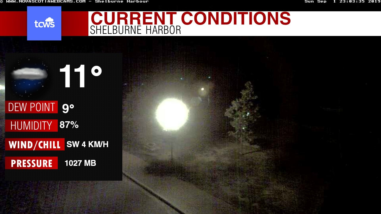 Good evening! Well it was another nice day today with plenty of sunshine and warm temperatures, and this will continue for 1 more day before we get some nice beneficial rainfall over the Tri-Counties by tomorrow night into Tuesday night. First let's take a look at the Current conditions, looking at live view of Beautiful Shelburne Harbor! where at this hour it is 11 degrees. Just a nice late summer evening. Now this high pressure that is north of us bringing us some cool mornings, lot's of sunshine and afternoon warmth is going to make it way over into Newfoundland by tomorrow and this will give us one more day of the long holiday weekend to enjoy the warmth & sunshine, because it ends Monday night. 
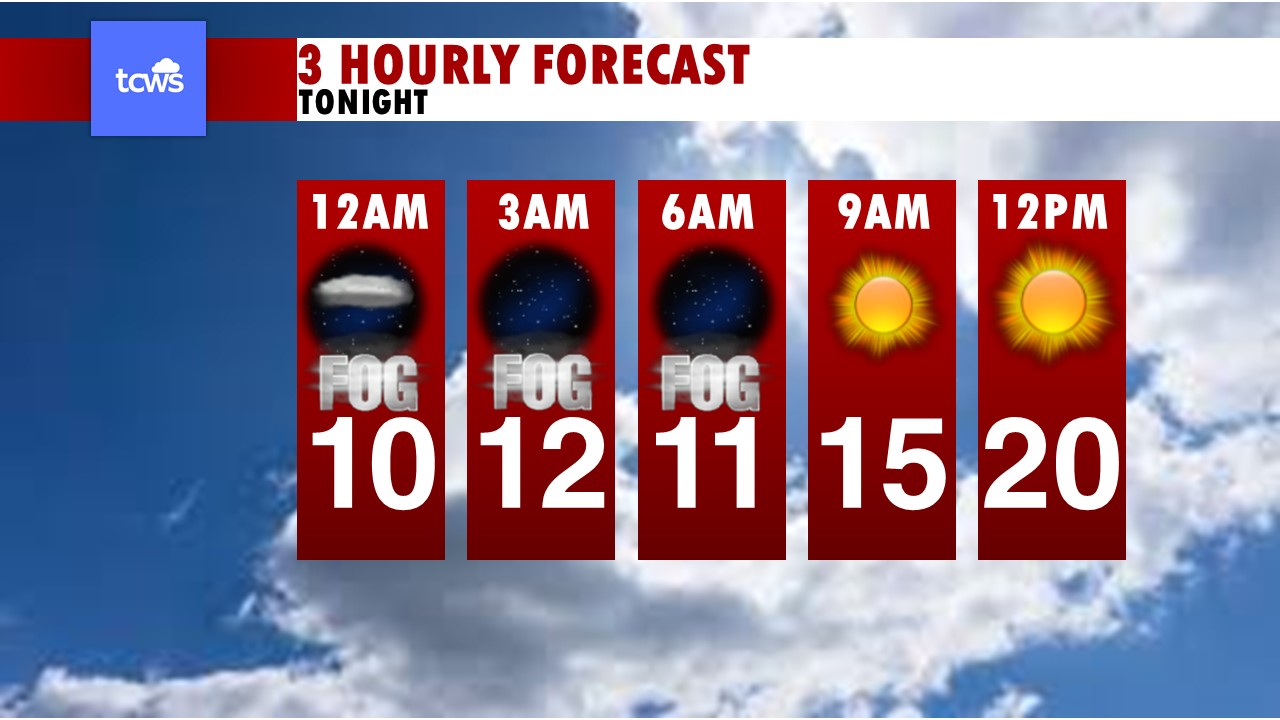 Until then though, Enjoy this beautiful weather. Here is your Hourly forecast: by 3am, it's clear skies and 12 degrees, we will see some fog patches develop! by 6am, clear skies and near 11 degrees, patchy fog. We see sunshine continue at 9am and noon with temperatures rising 15-20 degrees. Looking at your Holiday Monday forecast, looking at sunshine much of the day, we will see increase clouds as we get into the latter part of the afternoon, especially in Digby county. Highs once again in the low to mid-20's and winds from the south-West at 10-20km/h. 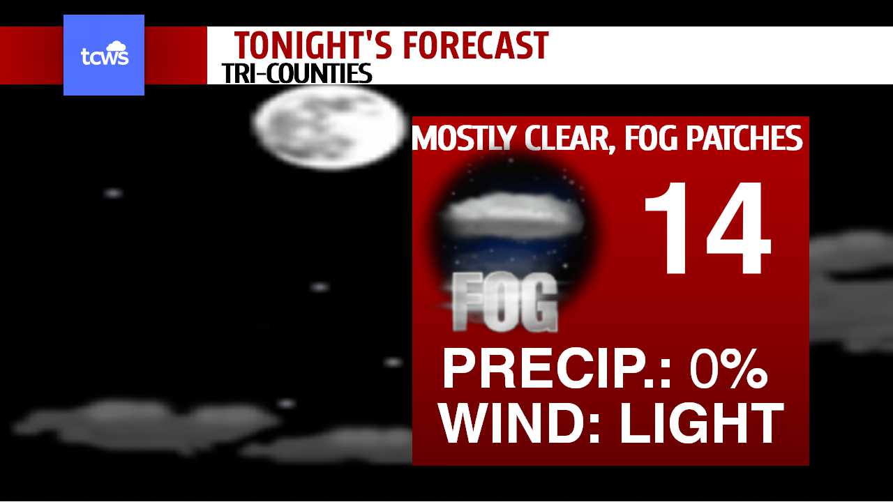 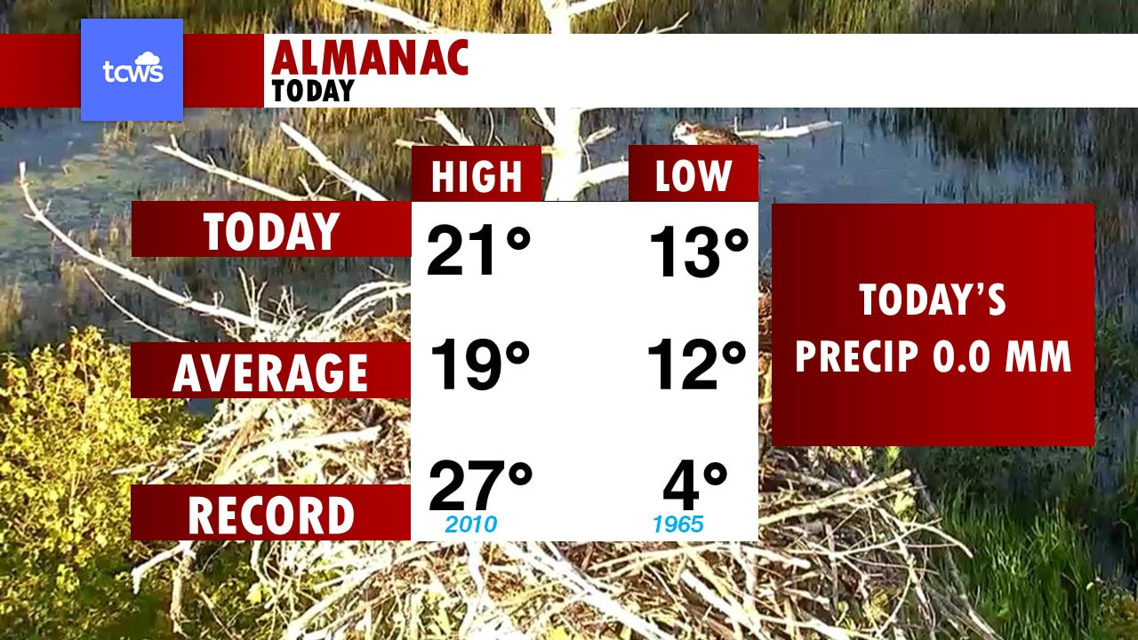 Looking at the Almanac for Today in Yarmouth, Hit 21 degrees today, Average is 19, our record today is 27 degrees from back in 2010, just 9 years ago! Our low this morning was 13, The average is 12, so just 1 degree above and our record low was back in 1965 at a cool 4 degrees. Once again, we had no rainfall recorded today. Kids are going back to school soon! on Thursday, here is a sneak peak at Thursday's School Bell forecast: 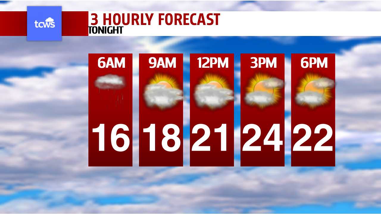 cold front will come through in early morning hours with some showers and storms, but that looks to clear out by noon time to give us increasing sunshine and very warm temperatures when get on bus to head home. by 7am at bus stop, looking at temps in the low-10's with showers and drizzle, and perhaps a rumble of thunder and so you may want to bring a light spring jacket and umbrella when head out the door. By noon, we are at already into the lower 20's with showers departing, and by 3pm it's a hot 26 degrees with mostly sunny skies. Now, we have Hurricane Dorian to talk about! Latest update from the NHC, shows that Dorian has weakened ever so slightly to 180mph, making her still a very strong Category 5 hurricane. Dorian remains an incredibly powerful hurricane and it is currently making landfall on the eastern end of Grand Bahama Island. Satellite images show an symmetrical cyclone with a circular 10 n mi diameter eye and intense eyewall convection with lots of lightning being detected. Doppler radar data from Miami and the Bahamas show that Dorian has developed concentric eyewalls, and this feature is also noted by a double wind maximum that is evident in data from the Air Force Hurricane Hunters. The initial intensity of Dorian is set at 155 kt based mostly on the SFMR winds from the aircraft. The aircraft data also indicated that the radii of tropical-storm-force winds are a little larger than they were earlier today. Dorian is still moving slowly westward at about 5 kt. The ridge to the north of Dorian is gradually weakening and shifting eastward in response to a mid- to upper-level trough that is moving across the eastern U.S. This change in the steering pattern should cause Dorian to slow down even more and perhaps stall, before it turns to the northwest late Monday or early Tuesday. This expected slow motion will likely be devastating to the Great Abaco and Grand Bahama Islands since it would prolong the catastrophic winds, storm surge, and rainfall over those areas. The timing of the northwest or north turn is very critical in determining how close Dorian will get to the Florida peninsula on Tuesday and Wednesday. In general, the track models have changed little from the previous cycle. it is still to early, to say what impact Dorian may have in our own back yard, but timing looks to be Early Saturday morning and the models are in good agreement that the storm will stay offshore, but be very close to land that heavy rain and very strong winds of Tropical storm force, perhaps minimal Hurricane force on the coast. GFS model has been pretty consistent so far.. and shows the storm just off Shelburne by Saturday morning, as of now.. it looks like VERY heavy rainfall of 80 to 120mm, combined with winds SUSTAINED near the coast at 70 to 100 km/h! Which is Tropical Storm force, wind Gusts on the coast will likely reach 100-120 km/h nearing Hurricane Strength, so even with this storm offshore, some moderate wind damage to buildings and property is likely, some serious tree damage and power outages. and because of the heavy rain, flooding problems as well, especially with storm surge of 5 to 15 ft above normal. So we will have to watch this storm over next several days, so stay tuned! Here now is your forecast, Tonight looking at those clear skies and cool temperatures, winds being light which will create some fog on the coast. Lows in the lower 10's to perhaps even upper 5's far inland. Tomorrow, lot's of sunshine, clouds building in the afternoon, winds becoming SE 10-20km/h. highs in the low 20's. Tomorrow Night, rain developing in Yarmouth & Digby late evening, cloudy skies and drizzle for Shelburne. Winds SE 10-20km/h. lows near 15. Here now is your 7 day forecast! Starting with Digby county, rain on your Tuesday with amounts of 5 to 15mm, highs in the low 20's. We get back to sunshine and hot temperatures on Wednesday with highs of 26, Morning showers giving way to sunshine on Thursday for the first day of school with highs in the low 20's. Friday will see increasing clouds ahead of Hurricane Dorian, highs near 20 and then for next weekend, Heavy rain and wind from Dorian on Saturday, highs of 16 and that Hurricane will make for a Gorgeous Sunday! sunshine and a chilly start in the mid single digits, but warm up into the low 20's in the afternoon. For Yarmouth county, Rain on Tuesday and cooler, with highs near 20. Sunny skies and hot temperatures return for Wednesday at 26 degrees, stays warm on Thursday with morning showers and afternoon sunshine, highs of 24. Cooler and cloudier on Friday with rain developing in the afternoon from outer edges of Dorian, highs of 19 and cooler Saturday as Dorian makes a close pass by that will drench us in heavy rain and high winds, highs of 16. Sunday is gorgeous! with sunshine and 24 degrees, chilly morning! at 7 degrees. and lastly for Shelburne, Rain showers on Tuesday and 22 degrees, Sunny and hot Wednesday at 27, 26 on Thursday with Am showers for first day back to school. Friday mostly cloudy and developing afternoon rain. highs of 19, Heavy rain and high winds from Dorian on Saturday, highs of 21 and sunshine and heat returns Sunday at 24, but waking up to a cool 7 in the AM. Have a great night! ~James |
AuthorThis is where our forecasters will post the forecast updates at the normal update times. Archives
April 2024
Categories |


 RSS Feed
